
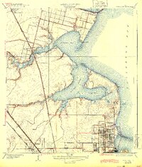
1932 Map of Texas City
USGS Topo · Published 1932About this map
Texas City is depicted here as a developing industrial and maritime hub along the western shore of Galveston Bay. The gridded streets of the city contrast sharply with the surrounding coastal lowlands, where water and land intermix at Moses Lake and Dollar Bay. Of particular note is the substantial Texas City Dike extending into the bay, a major piece of infrastructure alongside the Dredge Dumps that illustrates the early 20th-century engineering required to maintain this deepwater port.
Find a feature on this map
23 named features on this map. Tap any name to fly to it.
Don’t see what you’re looking for? This feature index may not catch every label — zoom into the map to look around manually.
Map Details
Editions of this 1932 Texas City Map
2 editions found
Other maps of this area

1916 · Seabrook
USGS Topo · 1:24,000

1920 · Seabrook
USGS Topo · 1:31,680

1929 · Dickinson
USGS Topo · 1:24,000

1929 · Hitchcock
USGS Topo · 1:24,000

1929 · Virginia Point
USGS Topo · 1:24,000

1929 · Texas City
USGS Topo · 1:24,000

1930 · Galveston
USGS Topo · 1:24,000

1932 · Clifton By The Sea
USGS Topo · 1:31,680

1932 · Dickinson
USGS Topo · 1:31,680
1932 · Seabrook
USGS Topo · 1:31,680