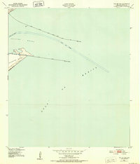
1943 Map of The Jetties
USGS Topo · Published 1952About this map
Bolivar Roads serves as the central focal point of this coastal survey, where the deep waters of the Gulf of Mexico meet the entrance to the harbor. The geography is defined by two massive engineering projects: the North Jetty, extending from the tip of the Bolivar Peninsula, and the South Jetty, which reaches out from the northern end of Galveston Island. Navigational safety for the Inner Bar Channel and Outer Bar Channel is marked by a series of maritime landmarks, including the South Jetty Lighthouse and the North Jetty Light. The map also captures several smaller navigational aids such as Beta, Beak, and Delta. This document illustrates the critical shipping infrastructure required to manage the shifting sands of East Beach and maintain the gateway to one of the most vital ports on the Texas coast during the early 1940s.
Find a feature on this map
17 named features on this map. Tap any name to fly to it.
Don’t see what you’re looking for? This feature index may not catch every label — zoom into the map to look around manually.
Map Details
Editions of this 1943 The Jetties Map
This is the sole edition of this map. No revisions or reprints were ever made.
Other maps of this area

1930 · Galveston
USGS Topo · 1:24,000

1931 · Flake
USGS Topo · 1:24,000

1932 · Bolivar Point
USGS Topo · 1:24,000

1933 · Caplen
USGS Topo · 1:31,680

1933 · The Jetties
USGS Topo · 1:31,680

1933 · Bolivar Point
USGS Topo · 1:31,680

1933 · Flake
USGS Topo · 1:31,680
1933 · Galveston
USGS Topo · 1:31,680
1943 · Flake
USGS Topo · 1:25,000
1943 · Port Bolivar
USGS Topo · 1:24,000