
1933 Map of Bolivar Point
USGS Topo · Published 1933About this map
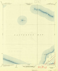
Galveston Bay dominates this maritime survey, illustrating the complex coastal geography of the Texas Gulf Coast in the early 1930s. The map highlights the strategic and navigational features essential to the region, including the elongated Hannah Reef and the isolated Hannah Island. Along the lower reaches, the Bolivar Peninsula extends toward the entrance of the bay, featuring Bolivar Point and the tactical positioning of the G C & S F railroad. A striking industrial feature is the Texas City Dike, stretching significantly into the water from the western shore. This edition was compiled using early aerial photography from the Army Air Corps, providing a specialized look at the shoreline and bathymetry before modern coastal developments altered these tidal environments.
Find a feature on this map
8 named features on this map. Tap any name to fly to it.
Don’t see what you’re looking for? This feature index may not catch every label — zoom into the map to look around manually.
Map Details
Editions of this 1933 Bolivar Point Map
2 editions found
Other maps of this area

1929 · Virginia Point
USGS Topo · 1:24,000

1929 · Texas City
USGS Topo · 1:24,000

1930 · Galveston
USGS Topo · 1:24,000

1931 · Flake
USGS Topo · 1:24,000

1932 · Clifton By The Sea
USGS Topo · 1:31,680

1932 · Texas City
USGS Topo · 1:31,680

1932 · Bolivar Point
USGS Topo · 1:24,000

1932 · Virginia Point
USGS Topo · 1:31,680

1933 · The Jetties
USGS Topo · 1:31,680

1933 · Whites Lake
USGS Topo · 1:31,680