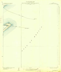
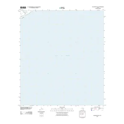
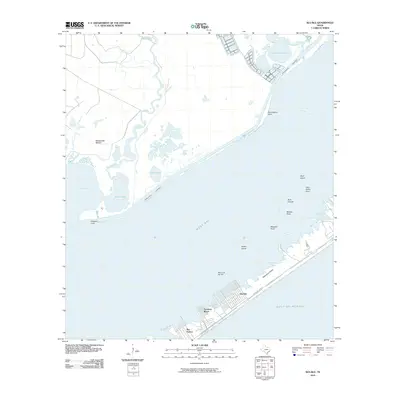
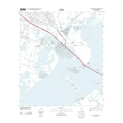
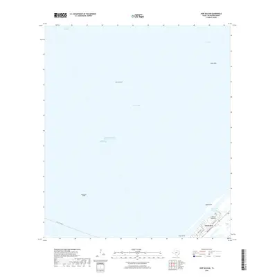
1933 Map of The Jetties
USGS Topo · Published 1933About this map
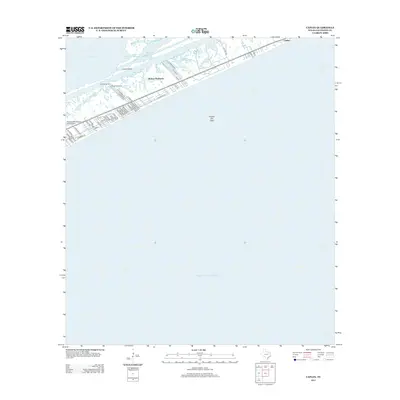
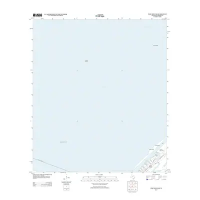
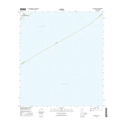
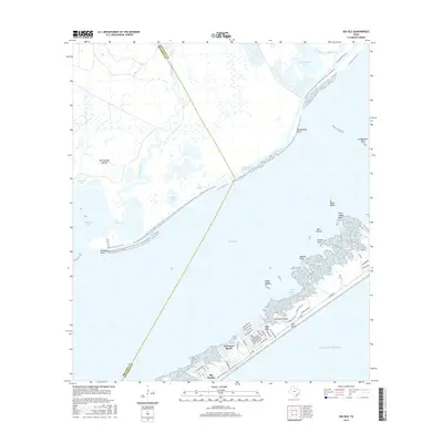
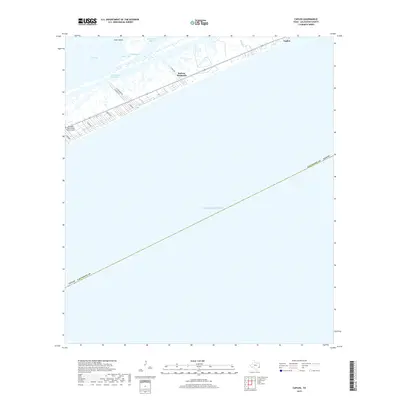
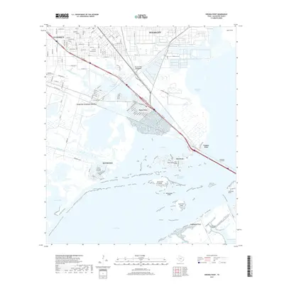
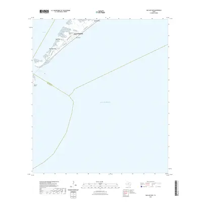
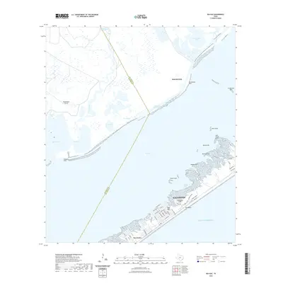
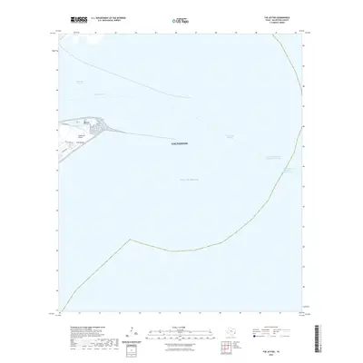
The maritime gateway to the Texas coast is defined by massive engineering works in this early 1930s survey, conducted by the Department of the Interior and U.S. Geological Survey in cooperation with the County Commissioners Court. The map focuses on the critical navigation channel between the southern tip of Bolivar Peninsula and the eastern edge of Galveston Island. Two prominent stone breakwaters, the North Jetty and South Jetty, extend miles into the Gulf of Mexico to protect the harbor entrance. At the terminus of these structures stand the North Jetty LH and Galveston Jetty LH, serving as essential navigational aids for vessels entering the port. On the island, Jetty Road provides access to the shoreline at East Beach, illustrating the coastal infrastructure prior to mid-century development.
Find a feature on this map
9 named features on this map. Tap any name to fly to it.
Don’t see what you’re looking for? This feature index may not catch every label — zoom into the map to look around manually.
Map Details
Editions of this 1933 The Jetties Map
2 editions found
Historical Maps of Galveston Through Time
96 maps found

1929 Algoa
Galveston County, TX

1929 Karankawa Lake
Galveston County, TX

1929 Virginia Point
Galveston County, TX

1931 Flake
Galveston County, TX

1931 Lake Como
Galveston County, TX

1932 Algoa
Galveston County, TX

1932 Bolivar Point
Galveston County, TX

1932 Virginia Point
Galveston County, TX

1933 Bolivar Point
Galveston County, TX

1933 Caplen
Galveston County, TX

1933 Carancahua Lake
Galveston County, TX

1933 Flake
Galveston County, TX

1933 Lake Como
Galveston County, TX

1933 San Luis Pass
Galveston County, TX

1933 The Jetties
Galveston County, TX

1943 Caplen
Galveston County, TX

1943 Carancahua Lake
Galveston County, TX

1943 Flake
Galveston County, TX

1943 Lake Como
Galveston County, TX

1943 Port Bolivar
Galveston County, TX

1943 San Luis Pass
Galveston County, TX

1943 The Jetties
Galveston County, TX

1943 Virginia Point
Galveston County, TX

1954 Caplen
Galveston County, TX

1954 Flake
Galveston County, TX

1954 Lake Como
Galveston County, TX

1954 Port Bolivar
Galveston County, TX

1954 The Jetties
Galveston County, TX

1954 Virginia Point
Galveston County, TX

1956 Algoa
Galveston County, TX

1963 San Luis Pass
Galveston County, TX

1963 Sea Isle
Galveston County, TX

1994 Caplen
Galveston County, TX

1994 Flake
Galveston County, TX

1994 Lake Como
Galveston County, TX

1994 Port Bolivar
Galveston County, TX

1994 The Jetties
Galveston County, TX

1994 Virginia Point
Galveston County, TX

1995 Virginia Point
Galveston County, TX
2010 Algoa
Galveston County, TX
2010 Caplen
Galveston County, TX
2010 Flake
Galveston County, TX
2010 Galveston OE S
Galveston County, TX
2010 Lake Como
Galveston County, TX
2010 Port Bolivar
Galveston County, TX
2010 San Luis Pass
Galveston County, TX
2010 Sea Isle
Galveston County, TX
2010 The Jetties
Galveston County, TX
2010 Virginia Point
Galveston County, TX
2013 Algoa
Galveston County, TX
2013 Caplen
Galveston County, TX
2013 Flake
Galveston County, TX
2013 Galveston OE S
Galveston County, TX
2013 Lake Como
Galveston County, TX
2013 Port Bolivar
Galveston County, TX
2013 San Luis Pass
Galveston County, TX
2013 Sea Isle
Galveston County, TX
2013 The Jetties
Galveston County, TX
2013 Virginia Point
Galveston County, TX
2016 Algoa
Galveston County, TX
2016 Caplen
Galveston County, TX
2016 Flake
Galveston County, TX
2016 Galveston OE S
Galveston County, TX
2016 Lake Como
Galveston County, TX
2016 Port Bolivar
Galveston County, TX
2016 San Luis Pass
Galveston County, TX
2016 Sea Isle
Galveston County, TX
2016 The Jetties
Galveston County, TX
2016 Virginia Point
Galveston County, TX
2019 Algoa
Galveston County, TX
2019 Caplen
Galveston County, TX
2019 Flake
Galveston County, TX
2019 Galveston OE S
Galveston County, TX
2019 Lake Como
Galveston County, TX
2019 Port Bolivar
Galveston County, TX
2019 San Luis Pass
Galveston County, TX
2019 Sea Isle
Galveston County, TX
2019 The Jetties
Galveston County, TX
2019 Virginia Point
Galveston County, TX

2022 Algoa
Galveston County, TX
2022 Caplen
Galveston County, TX
2022 Flake
Galveston County, TX

2022 Galveston OE S
Galveston County, TX
2022 Lake Como
Galveston County, TX

2022 Port Bolivar
Galveston County, TX
2022 San Luis Pass
Galveston County, TX
2022 Sea Isle
Galveston County, TX
2022 The Jetties
Galveston County, TX

2022 Virginia Point
Galveston County, TX

2025 Caplen
Galveston County, TX

2025 Flake
Galveston County, TX

2025 Galveston OE S
Galveston County, TX

2025 Lake Como
Galveston County, TX

2025 San Luis Pass
Galveston County, TX

2025 Sea Isle
Galveston County, TX

2025 The Jetties
Galveston County, TX