1933 Map of Caplen
USGS Topo · Published 1933About this map
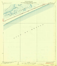
Bolivar Peninsula stretches across this coastal survey, documenting a narrow strip of land between the Gulf of Mexico and East Bay. The landscape is defined by the marshy indentations of Pasture Bayou and Yates Bayou, which cut into the northern shoreline. Small coastal settlements like Caplen and Patton anchor the local community, served by a transit corridor that includes the Santa Fe railroad and State Highway No 124. Surveyed in 1931, the map utilizes aerial photography from the U.S. Army Air Corps to chart the complex drainage and shoreline, revealing a sparsely populated but critical connection between the mainland and the Gulf. The presence of the Gulf and Colorado line further emphasizes the peninsula's role as a transportation artery during the early 1930s.
Find a feature on this map
10 named features on this map. Tap any name to fly to it.
Don’t see what you’re looking for? This feature index may not catch every label — zoom into the map to look around manually.
Map Details
Editions of this 1933 Caplen Map
2 editions found
Historical Maps of Bolivar Peninsula Through Time
49 maps found

1929 Algoa
Galveston County, TX

1929 Karankawa Lake
Galveston County, TX

1929 Virginia Point
Galveston County, TX

1931 Flake
Galveston County, TX

1931 Lake Como
Galveston County, TX

1932 Algoa
Galveston County, TX

1932 Bolivar Point
Galveston County, TX

1932 Virginia Point
Galveston County, TX

1933 Bolivar Point
Galveston County, TX

1933 Caplen
Galveston County, TX

1933 Carancahua Lake
Galveston County, TX

1933 Flake
Galveston County, TX

1933 Lake Como
Galveston County, TX

1933 San Luis Pass
Galveston County, TX

1933 The Jetties
Galveston County, TX

1943 Caplen
Galveston County, TX

1943 Carancahua Lake
Galveston County, TX

1943 Flake
Galveston County, TX

1943 Lake Como
Galveston County, TX

1943 Port Bolivar
Galveston County, TX

1943 San Luis Pass
Galveston County, TX

1943 The Jetties
Galveston County, TX

1943 Virginia Point
Galveston County, TX

1954 Caplen
Galveston County, TX

1954 Flake
Galveston County, TX

1954 Lake Como
Galveston County, TX

1954 Port Bolivar
Galveston County, TX

1954 The Jetties
Galveston County, TX

1954 Virginia Point
Galveston County, TX

1956 Algoa
Galveston County, TX

1963 San Luis Pass
Galveston County, TX

1963 Sea Isle
Galveston County, TX

1994 Caplen
Galveston County, TX

1994 Flake
Galveston County, TX

1994 Lake Como
Galveston County, TX

1994 Port Bolivar
Galveston County, TX

1994 The Jetties
Galveston County, TX

1994 Virginia Point
Galveston County, TX

1995 Virginia Point
Galveston County, TX

2022 Algoa
Galveston County, TX

2022 Port Bolivar
Galveston County, TX

2022 Virginia Point
Galveston County, TX

2025 Caplen
Galveston County, TX

2025 Flake
Galveston County, TX

2025 Galveston OE S
Galveston County, TX

2025 Lake Como
Galveston County, TX

2025 San Luis Pass
Galveston County, TX

2025 Sea Isle
Galveston County, TX

2025 The Jetties
Galveston County, TX