
1933 Map of Frozen Point
USGS Topo · Published 1933About this map
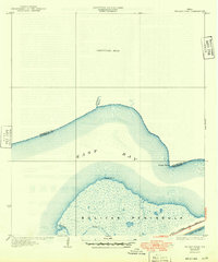
Bolivar Peninsula stretches across this 1933 preliminary survey, showcasing a landscape of tidal marshes and coastal waterways before extensive modern development. This sheet captures a critical segment of the Texas coast where East Bay meets the mainland, featuring the namesake Frozen Point on the marshy northern shore. The era's infrastructure is dominated by the Gulf Colorado and Santa Fe State Highway No 124, which provides a vital land link across the peninsula. Smaller waterways like Robinson Bayou and Pasture Bayou snake through the terrain, illustrating the natural drainage patterns of the upper coast. Prepared with the assistance of Galveston County Engineer C. C. Washington and aerial photography from the U.S. Army Air Corps, the map serves as a detailed record of the shoreline and maritime boundary between Chambers and Galveston counties.
Find a feature on this map
9 named features on this map. Tap any name to fly to it.
Don’t see what you’re looking for? This feature index may not catch every label — zoom into the map to look around manually.
Map Details
Editions of this 1933 Frozen Point Map
2 editions found
Other maps of this area

1931 · Flake
USGS Topo · 1:24,000

1931 · High Island
USGS Topo · 1:24,000

1931 · Frozen Point
USGS Topo · 1:24,000

1933 · Caplen
USGS Topo · 1:31,680

1933 · Whites Lake
USGS Topo · 1:31,680

1933 · Flake
USGS Topo · 1:31,680

1943 · High Island
USGS Topo · 1:31,680
1943 · Flake
USGS Topo · 1:25,000

1943 · Frozen Point
USGS Topo · 1:24,000
1943 · Lake Stephenson
USGS Topo · 1:24,000