Old Maps of Rollover, Texas
Explore 10 old maps of Rollover, spanning from 1931 to today. These high-resolution historic maps reveal how streets, neighborhoods, landmarks, and natural features evolved over time — perfect for genealogy, metal detecting, research, and local history exploration.
What you can do with these maps:
- See how Rollover changed over time: Compare historical maps to modern-day views to trace roads, homesites, rail lines & more.
- View detailed metadata: Each map includes creators, publishers, year, scale, and archive source.
- Overlay maps with satellite & LiDAR: Visualize the past alongside modern tools to explore terrain & human change.
- Trusted historical sources: Maps sourced from the USGS, Library of Congress, and other archives.
- Access maps your way: View online, download high-res files, or order prints for personal or research use.
Start exploring old maps of Rollover to uncover forgotten places, hidden landmarks, and the deep history beneath your feet.
Rollover, TX maps
(10)- 1931 Map of Frozen Point
 1931 Frozen Point1931 Print · USGSCoastal Chambers and Galveston counties are shown in the early 1930s just as aerial photography began to modernize mapping. Trace the shoreline of East Bay and the rail line of the Gulf Colorado and Santa Fe at Frozen Point.
 - 1933 Map of Frozen Point
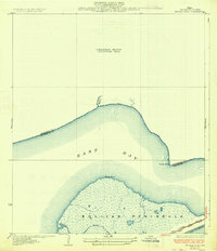 1933 Frozen Point1933 Print · USGSThe Texas coastline on the Bolivar Peninsula is captured here in the early 1930s, showing a world of tidal marshes and remote shorelines. Trace the route of the Gulf Colorado and Santa Fe State Highway No 124 and the natural reach of Robinson Bayou.2 unique versions available
 - 1943 Map of Frozen Point, 1952 Print
 1943 Frozen Point1952 Print · USGSThe Texas coast near the Bolivar Peninsula is captured here during the early forties, showing a landscape defined by expansive salt marshes and new industrial waterways. Researchers can trace the development of the Intracoastal Waterway and locate early sites like Rollover and the Sun Oil Company Canal.
 - 1950 Map of Houston, 1953 Print
 1950 Houston1953 Print · USGSCoastal Texas in the early fifties reveals a landscape of massive civil engineering and industrial transit. Genealogists and researchers can trace the growth of the Houston suburbs and the maritime infrastructure of Galveston Bay, including the Gulf Freeway and the Texas City Dike.
 - 1956 Map of Houston, 1963 Print
 1956 Houston1963 Print · USGSSoutheast Texas in the mid-fifties is captured here as a powerhouse of oil and maritime trade. Genealogists and historians can trace the foundations of Houston and its ports, alongside landmarks like the Rice Institute and the Spindletop Oil Field.2 unique versions available
 - 1962 Map of Frozen Point, 1964 Print
 1962 Frozen Point1964 Print · USGSCoastal Texas life and industry intersect along the Bolivar Peninsula and East Bay in the early sixties. Genealogists and researchers can trace the old settlement at Caplen, the development of the East Robinson Lake Gas Field, and the path of the Sun Oil Company Canal.
 - 1975 Map of Houston, 1977 Print
 1975 Houston1977 Print · USGSThe Texas Gulf Coast in the mid-seventies shows a sprawling Houston metropolis linked to the sea by the massive Houston Ship Channel. Researchers can trace the mid-century industrial landscape from the Astrodome to the Lyndon B. Johnson Space Center.2 unique versions available
 - 1983 Map of Anahuac
 1983 Anahuac1983 Print · USGSThe Upper Texas Coast and its energy-driven landscape are detailed here in the early eighties. Genealogists and historians can trace coastal settlements like Anahuac and Winnie alongside the storied Spindletop Oil Field and the Anahuac National Wildlife Refuge.2 unique versions available
 - 1994 Map of Frozen Point
 1994 Frozen Point1994 Print · USGSCoastal Texas marshes and the barrier islands of Chambers County are captured here during the 1990s. Researchers can trace the industrial footprints of the Sun Oil Company Canal and Oil Wells alongside settlements like Caplen and Pierce.
 - 2025 Map of Frozen Point, 2025 Print
 2025 Frozen Point2025 Print · USGSThe coastal marshes and bays of the Texas Gulf Coast come into sharp focus in this mid-2020s survey. Researchers can trace the shifting shorelines of the Bolivar Peninsula and the remote settlements near Caplen and Rollover Bay.
End of results
Showing maps 1-10 of 10
Top cities near Rollover
Frequently asked questions
- What are the different types of historical maps available for Rollover?
- What is the oldest map of Rollover?
- Where can I purchase historical maps of Rollover for my home or office?
- Where can I download high-res historical maps of Rollover?
- Are there historical topographic maps available for Rollover?
- Is there historical aerial imagery available for Rollover?
- Where are historical maps of Rollover sourced from?