1960s Maps of Grayson County, Texas
Explore 5 historic maps of Grayson County from the 1960s. These maps offer a rare glimpse into what life looked like during the 1960s — showing old roads, neighborhoods, homes, and landmarks that have changed or disappeared over time.
Whether you're researching your family's past, planning a metal detecting trip, or studying how Grayson County's landscape evolved across the 1960s, these high-resolution maps are a powerful tool for exploring the history of this region.
- Focus on a specific era: All maps on this page are from the 1960s, giving you a focused view of this time period.
- See what’s changed: Compare century-old streets, trails, and buildings to today's modern landscape using overlays and satellite layers.
- Research with precision: Use these maps for genealogy, historical research, land use analysis, or educational projects.
- View, download, or print: Maps are fully viewable online in high resolution, and can be downloaded or printed for your own records.
Start exploring Grayson County's history through authentic maps from the 1960s. This is your window into the past.
Grayson County, TX maps
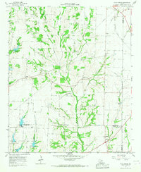
(5)- 1961 Map of Gunter, 1963 Print
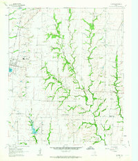 1961 Gunter1963 Print · USGSThis early 1960s survey of the North Texas prairies captures the border between Grayson and Collin counties as the rural landscape began its modern shift. Genealogists and local historians can locate several family burial grounds, including Smallwood Cem and Forbis Cem, and trace the path of the ST LOUIS SAN FRANCISCO railroad.2 unique versions available
 - 1961 Map of Van Alstyne, 1963 Print
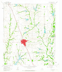 1961 Van Alstyne1963 Print · USGSGrayson and Collin counties are captured here in the early sixties as agricultural life and the railroad define the landscape. Genealogists can trace family names at Morris Cem and Baker Cem or locate the rural Sister Grove Ch along the winding prongs of the local creeks.2 unique versions available
 - 1961 Map of Pilot Point, 1963 Print
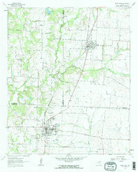 1961 Pilot Point1963 Print · USGSDenton and Grayson Counties are seen here in the early sixties, centered on the railroad corridor through the Texas prairie. Local historians can trace the foundations of Tioga and Pilot Point, locating sites like Gee High Sch, the Masonic Cem, and Tipton Chapel.3 unique versions available
 - 1961 Map of Marilee, 1963 Print
 1961 Marilee1963 Print · USGSThe rural borderlands of Grayson, Denton, and Collin counties come into focus in the early sixties as the railroad era meets modern infrastructure. Trace the tracks of the St Louis San Francisco and Texas rail line through Marilee or locate local landmarks like Mt Carmel Ch and Gunter Cem.2 unique versions available
 - 1964 Map of Pilot Grove, 1967 Print
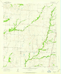
 1964 Pilot Grove1967 Print · USGSNear the intersection of Grayson, Fannin, and Collin counties in the mid-1960s, this rural landscape centers on the Pilot Grove Creek forks. Researchers can trace family history through local landmarks like Worden Cem, Starks Chapel Ch, and the settlement of Pilot Grove.2 unique versions available
End of results
Showing maps 1-5 of 5
Top cities of Grayson County
- Sherman historical maps
- Denison historical maps
- Van Alstyne historical maps
- Whitesboro historical maps
- Howe historical maps
- Pottsboro historical maps
See more
Frequently asked questions
- What are the different types of historical maps available for Grayson County?
- What is the oldest map of Grayson County?
- Where can I purchase historical maps of Grayson County for my home or office?
- Where can I download high-res historical maps of Grayson County?
- Are there historical topographic maps available for Grayson County?
- Is there historical aerial imagery available for Grayson County?
- Where are historical maps of Grayson County sourced from?