1960s Maps of Plainview, Texas
Explore 2 historic maps of Plainview from the 1960s. These maps offer a rare glimpse into what life looked like during the 1960s — showing old roads, neighborhoods, homes, and landmarks that have changed or disappeared over time.
Whether you're researching your family's past, planning a metal detecting trip, or studying how Plainview's landscape evolved across the 1960s, these high-resolution maps are a powerful tool for exploring the history of this region.
- Focus on a specific era: All maps on this page are from the 1960s, giving you a focused view of this time period.
- See what’s changed: Compare century-old streets, trails, and buildings to today's modern landscape using overlays and satellite layers.
- Research with precision: Use these maps for genealogy, historical research, land use analysis, or educational projects.
- View, download, or print: Maps are fully viewable online in high resolution, and can be downloaded or printed for your own records.
Start exploring Plainview's history through authentic maps from the 1960s. This is your window into the past.
Plainview, TX maps
(2)- 1965 Map of Wasson, 1968 Print
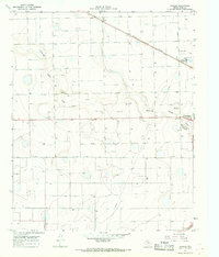 1965 Wasson1968 Print · USGSHale County's agricultural landscape comes alive in the 1960s, showing the industrial infrastructure and small settlements north of the regional center. You can trace the path of the Aqueduct and locate sites like the Heck Cotton Gin and Boone.2 unique versions available
 - 1965 Map of Plainview, 1968 Print
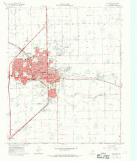 1965 Plainview1968 Print · USGSPlainview and its surrounding High Plains landscape are captured here in the mid-sixties as the city grew into a major regional hub. Trace the development of Wayland College, locate early neighborhood schools like Ash Sch, and see the rail-driven economy of Grain Elevators along the Fort Worth and Denver line.
End of results
Showing maps 1-2 of 2
Top cities near Plainview
Frequently asked questions
- What are the different types of historical maps available for Plainview?
- What is the oldest map of Plainview?
- Where can I purchase historical maps of Plainview for my home or office?
- Where can I download high-res historical maps of Plainview?
- Are there historical topographic maps available for Plainview?
- Is there historical aerial imagery available for Plainview?
- Where are historical maps of Plainview sourced from?