1910s Maps of Barrett, Texas
Explore 2 historic maps of Barrett from the 1910s. These maps offer a rare glimpse into what life looked like during the 1910s — showing old roads, neighborhoods, homes, and landmarks that have changed or disappeared over time.
Whether you're researching your family's past, planning a metal detecting trip, or studying how Barrett's landscape evolved across the 1910s, these high-resolution maps are a powerful tool for exploring the history of this region.
- Focus on a specific era: All maps on this page are from the 1910s, giving you a focused view of this time period.
- See what’s changed: Compare century-old streets, trails, and buildings to today's modern landscape using overlays and satellite layers.
- Research with precision: Use these maps for genealogy, historical research, land use analysis, or educational projects.
- View, download, or print: Maps are fully viewable online in high resolution, and can be downloaded or printed for your own records.
Start exploring Barrett's history through authentic maps from the 1910s. This is your window into the past.
Barrett, TX maps
(2)- 1916 Map of Crosby
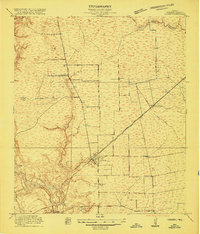 1916 Crosby1916 Print · USGSCoastal Texas prairie and river bottomlands come alive in this mid-1910s survey of Harris County. Researchers can trace early railroad junctions at Crosby or locate rural landmarks like Gum Gully School and the Adlong Ditch.2 unique versions available
 - 1919 Map of Crosby
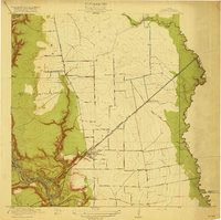 1919 Crosby1919 Print · USGSHarris County at the height of its early twentieth-century growth shows a landscape of rail-connected towns and rural school districts. Genealogists and local historians can trace family locations near Gum Gully School, Ramsey School, or the early Oil Pumping Sta.3 unique versions available
End of results
Showing maps 1-2 of 2
Top cities near Barrett
- Houston historical maps
- Pasadena historical maps
- Atascocita historical maps
- Kingwood historical maps
- Baytown historical maps
- Channelview historical maps
See more
Frequently asked questions
- What are the different types of historical maps available for Barrett?
- What is the oldest map of Barrett?
- Where can I purchase historical maps of Barrett for my home or office?
- Where can I download high-res historical maps of Barrett?
- Are there historical topographic maps available for Barrett?
- Is there historical aerial imagery available for Barrett?
- Where are historical maps of Barrett sourced from?