1910s Maps of The Meadows, Harris County
Explore 6 historic maps of The Meadows from the 1910s. These maps offer a rare glimpse into what life looked like during the 1910s — showing old roads, neighborhoods, homes, and landmarks that have changed or disappeared over time.
Whether you're researching your family's past, planning a metal detecting trip, or studying how The Meadows's landscape evolved across the 1910s, these high-resolution maps are a powerful tool for exploring the history of this region.
- Focus on a specific era: All maps on this page are from the 1910s, giving you a focused view of this time period.
- See what’s changed: Compare century-old streets, trails, and buildings to today's modern landscape using overlays and satellite layers.
- Research with precision: Use these maps for genealogy, historical research, land use analysis, or educational projects.
- View, download, or print: Maps are fully viewable online in high resolution, and can be downloaded or printed for your own records.
Start exploring The Meadows's history through authentic maps from the 1910s. This is your window into the past.
The Meadows, Harris County maps
(6)- 1915 Map of Cypress
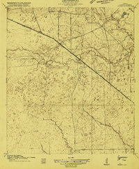 1915 Cypress1915 Print · USGSCoastal prairie and creek-side settlements define this Harris County area during the early twentieth century. Researchers can trace historic landholdings like Bains Ranch or find early educational sites including Big Cypress School and Brink School.3 unique versions available
 - 1916 Map of Rose Hill
 1916 Rose Hill1916 Print · USGSHarris County farming communities thrived along the Montgomery County line during the mid-1910s, years before suburban sprawl reached the area. Genealogists can trace early homesteads near Rose Hill and find historic rural landmarks like Cypress Church and the Bowers School.
 - 1916 Map of Hockley
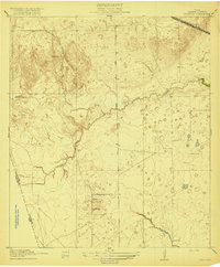
 1916 Hockley1916 Print · USGSUpper Harris County during the First World War shows a landscape defined by timber mills and early railroad junctions. Genealogists can locate family-named landmarks like Bauers Store and Hegar School, or trace the old Houston and Texas Central Road.
 - 1916 Map of Swanson, 1961 Print
 1916 Swanson1961 Print · USGSTexas ranching and rail history come together in this 1910s survey of western Harris County. Researchers can trace early family landholdings like Warren Ranch or locate the original path of the Southern Pacific System near Wolf Hill.
 - 1918 Map of Cypress
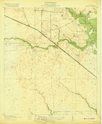 1918 Cypress1918 Print · USGSCypress and its surrounding prairie are documented here in the early 1900s, showing a rural Harris County landscape of ranching and creek-side schools. Genealogists and historians can trace family locations near Houston Hot Wells, Rams Ranch, or the Big Cypress School.2 unique versions available
 - 1919 Map of Swanson
 1919 Swanson1919 Print · USGSHarris and Waller counties appear here at the end of the Great War, showing the transition from open ranch land to a rail-connected economy. Genealogists and researchers can trace family-named landmarks like Warren Ranch, Lake Peter Donley, and Freemans Dam.2 unique versions available
End of results
Showing maps 1-6 of 6
Frequently asked questions
- What are the different types of historical maps available for The Meadows?
- What is the oldest map of The Meadows?
- Where can I purchase historical maps of The Meadows for my home or office?
- Where can I download high-res historical maps of The Meadows?
- Are there historical topographic maps available for The Meadows?
- Is there historical aerial imagery available for The Meadows?
- Where are historical maps of The Meadows sourced from?