1960s Maps of The Preserve, Texas
Explore 2 historic maps of The Preserve from the 1960s. These maps offer a rare glimpse into what life looked like during the 1960s — showing old roads, neighborhoods, homes, and landmarks that have changed or disappeared over time.
Whether you're researching your family's past, planning a metal detecting trip, or studying how The Preserve's landscape evolved across the 1960s, these high-resolution maps are a powerful tool for exploring the history of this region.
- Focus on a specific era: All maps on this page are from the 1960s, giving you a focused view of this time period.
- See what’s changed: Compare century-old streets, trails, and buildings to today's modern landscape using overlays and satellite layers.
- Research with precision: Use these maps for genealogy, historical research, land use analysis, or educational projects.
- View, download, or print: Maps are fully viewable online in high resolution, and can be downloaded or printed for your own records.
Start exploring The Preserve's history through authentic maps from the 1960s. This is your window into the past.
The Preserve, TX maps
(2)- 1962 Map of Oklahoma, 1963 Print
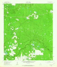 1962 Oklahoma1963 Print · USGSSoutheast Texas in the early sixties was a landscape of expanding oil fields and small rural settlements. Genealogists and historians can trace the foundations of Oklahoma and Egypt, locate the Zion Cem, and follow the Missouri Pacific rail line.4 unique versions available
 - 1962 Map of Tomball, 1964 Print
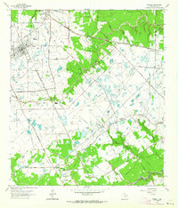 1962 Tomball1964 Print · USGSNorthwest Harris County in the early sixties was a landscape of expanding oil fields and legacy family farmsteads. Researchers can trace rural cemeteries like Huckabee Cem, the Hufsmith Oil Field, and early rail lines through Tomball and Kohrville.4 unique versions available
End of results
Showing maps 1-2 of 2
Top cities near The Preserve
- Houston historical maps
- Cypress historical maps
- The Woodlands historical maps
- Conroe historical maps
- Spring historical maps
- Aldine historical maps
See more
Top neighborhoods of The Preserve
Frequently asked questions
- What are the different types of historical maps available for The Preserve?
- What is the oldest map of The Preserve?
- Where can I purchase historical maps of The Preserve for my home or office?
- Where can I download high-res historical maps of The Preserve?
- Are there historical topographic maps available for The Preserve?
- Is there historical aerial imagery available for The Preserve?
- Where are historical maps of The Preserve sourced from?