1960s Maps of Uncertain, Texas
Explore 2 historic maps of Uncertain from the 1960s. These maps offer a rare glimpse into what life looked like during the 1960s — showing old roads, neighborhoods, homes, and landmarks that have changed or disappeared over time.
Whether you're researching your family's past, planning a metal detecting trip, or studying how Uncertain's landscape evolved across the 1960s, these high-resolution maps are a powerful tool for exploring the history of this region.
- Focus on a specific era: All maps on this page are from the 1960s, giving you a focused view of this time period.
- See what’s changed: Compare century-old streets, trails, and buildings to today's modern landscape using overlays and satellite layers.
- Research with precision: Use these maps for genealogy, historical research, land use analysis, or educational projects.
- View, download, or print: Maps are fully viewable online in high resolution, and can be downloaded or printed for your own records.
Start exploring Uncertain's history through authentic maps from the 1960s. This is your window into the past.
Uncertain, TX maps
(2)- 1962 Map of Potters Point, 1964 Print
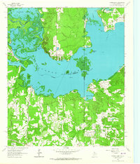 1962 Potters Point1964 Print · USGSCaddo Lake and the borderlands of Texas and Louisiana appear here in the early sixties, showing a landscape defined by its bayous and early industry. Trace the historic landings and settlements of Uncertain, Swansons Landing, and the riverside Elizabeth Ch.3 unique versions available
 - 1962 Map of Karnack, 1964 Print
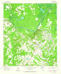 1962 Karnack1964 Print · USGSHarrison County in the early sixties reveals a landscape shaped by military industry and the winding waters of the Cypress Bayou. Researchers can trace the sprawling Longhorn Ordnance Works and the homes of Karnack and Baldwin.2 unique versions available
End of results
Showing maps 1-2 of 2
Top cities near Uncertain
- Shreveport historical maps
- Marshall historical maps
- Vivian historical maps
- Blanchard historical maps
- Waskom historical maps
- Jefferson historical maps
See more
Frequently asked questions
- What are the different types of historical maps available for Uncertain?
- What is the oldest map of Uncertain?
- Where can I purchase historical maps of Uncertain for my home or office?
- Where can I download high-res historical maps of Uncertain?
- Are there historical topographic maps available for Uncertain?
- Is there historical aerial imagery available for Uncertain?
- Where are historical maps of Uncertain sourced from?