1940s Maps of Murchison, Texas
Explore 4 historic maps of Murchison from the 1940s. These maps offer a rare glimpse into what life looked like during the 1940s — showing old roads, neighborhoods, homes, and landmarks that have changed or disappeared over time.
Whether you're researching your family's past, planning a metal detecting trip, or studying how Murchison's landscape evolved across the 1940s, these high-resolution maps are a powerful tool for exploring the history of this region.
- Focus on a specific era: All maps on this page are from the 1940s, giving you a focused view of this time period.
- See what’s changed: Compare century-old streets, trails, and buildings to today's modern landscape using overlays and satellite layers.
- Research with precision: Use these maps for genealogy, historical research, land use analysis, or educational projects.
- View, download, or print: Maps are fully viewable online in high resolution, and can be downloaded or printed for your own records.
Start exploring Murchison's history through authentic maps from the 1940s. This is your window into the past.
Murchison, TX maps
(4)- 1948 Map of Brownsboro, 1966 Print
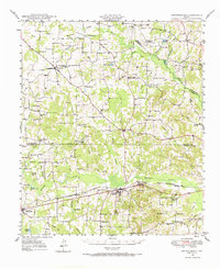 1948 Brownsboro1966 Print · USGSHenderson and Van Zandt counties appear here in the late 1940s as a landscape of rural schoolhouses and family cemeteries along the St Louis Southwestern rails. Genealogists can locate family landmarks like Old Norwegian Cem, Smith Chapel, and Prairie Springs Cem.
 - 1948 Map of Martins Mill, 1974 Print
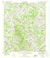 1948 Martins Mill1974 Print · USGSVan Zandt and Henderson counties are shown here in the late 1940s, revealing a landscape of small agricultural settlements and rural school districts. Genealogists can trace family roots through numerous sites like Liberty Cem, Walnut Sch, and the St Louis Southwestern Railroad corridor.
 - 1949 Map of Martins Mill
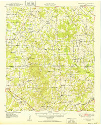 1949 Martins Mill1949 Print · USGSEast Texas rural life is preserved here in the late 1940s as farm-to-market roads linked the communities of Martins Mills and Murchison. Genealogists can trace family names through dozens of landmarks like Cool Springs Ch, Lone Star Sch, and Carter Cem.
 - 1949 Map of Brownsboro
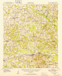 1949 Brownsboro1949 Print · USGSEast Texas at the end of the 1940s reveals a network of railroad towns and oil fields at the Henderson and Smith county line. Genealogy researchers can trace local family roots through sites like Old Norwegian Cem, Sexton Chapel, and Arc Ridge Sch.
End of results
Showing maps 1-4 of 4
Top cities near Murchison
- Athens historical maps
- Malakoff historical maps
- Brownsboro historical maps
- Eustace historical maps
- Edom historical maps
- Poynor historical maps
See more
Frequently asked questions
- What are the different types of historical maps available for Murchison?
- What is the oldest map of Murchison?
- Where can I purchase historical maps of Murchison for my home or office?
- Where can I download high-res historical maps of Murchison?
- Are there historical topographic maps available for Murchison?
- Is there historical aerial imagery available for Murchison?
- Where are historical maps of Murchison sourced from?