1980s Maps of Murchison, Texas
Explore 4 historic maps of Murchison from the 1980s. These maps offer a rare glimpse into what life looked like during the 1980s — showing old roads, neighborhoods, homes, and landmarks that have changed or disappeared over time.
Whether you're researching your family's past, planning a metal detecting trip, or studying how Murchison's landscape evolved across the 1980s, these high-resolution maps are a powerful tool for exploring the history of this region.
- Focus on a specific era: All maps on this page are from the 1980s, giving you a focused view of this time period.
- See what’s changed: Compare century-old streets, trails, and buildings to today's modern landscape using overlays and satellite layers.
- Research with precision: Use these maps for genealogy, historical research, land use analysis, or educational projects.
- View, download, or print: Maps are fully viewable online in high resolution, and can be downloaded or printed for your own records.
Start exploring Murchison's history through authentic maps from the 1980s. This is your window into the past.
Murchison, TX maps
(4)- 1984 Map of Tyler
 1984 Tyler1984 Print · USGSEast Texas at the peak of its reservoir-building era shows a landscape defined by new lakes and established rail corridors. Trace the path of the St Louis Southwestern RR or locate industrial sites like the Longhorn Ordnance Works.3 unique versions available
 - 1984 Map of Murchison East
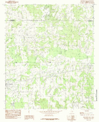 1984 Murchison East1984 Print · USGSHenderson and Van Zandt Counties were transitioning through a period of rural industrialization in the mid-1980s. Local researchers can trace the development of the Refinery near Opelika or locate family sites around Murchison, Brownsboro, and Edom.
 - 1984 Map of Murchison West
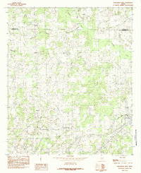 1984 Murchison West1984 Print · USGSThe Henderson and Van Zandt county line comes alive in the late seventies and early eighties, showing a landscape of rural crossroads and creek-fed bottomlands. Researchers can trace the development of Murchison, locate the community at Bethel, and follow the waters of Kickapoo Creek and Jackson Lake.
 - 1985 Map of Tyler
 1985 Tyler1985 Print · USGSEast Texas in the mid-eighties centers on the growth of Tyler and the expansive waters of Lake Palestine. Genealogists and researchers can trace family landmarks like Henry's Chapel and Browning Cem alongside the routes of the Southern Pacific RR.
End of results
Showing maps 1-4 of 4
Top cities near Murchison
- Athens historical maps
- Malakoff historical maps
- Brownsboro historical maps
- Eustace historical maps
- Edom historical maps
- Poynor historical maps
See more
Frequently asked questions
- What are the different types of historical maps available for Murchison?
- What is the oldest map of Murchison?
- Where can I purchase historical maps of Murchison for my home or office?
- Where can I download high-res historical maps of Murchison?
- Are there historical topographic maps available for Murchison?
- Is there historical aerial imagery available for Murchison?
- Where are historical maps of Murchison sourced from?