1940s Maps of Monte Christo, Texas
Explore 2 historic maps of Monte Christo from the 1940s. These maps offer a rare glimpse into what life looked like during the 1940s — showing old roads, neighborhoods, homes, and landmarks that have changed or disappeared over time.
Whether you're researching your family's past, planning a metal detecting trip, or studying how Monte Christo's landscape evolved across the 1940s, these high-resolution maps are a powerful tool for exploring the history of this region.
- Focus on a specific era: All maps on this page are from the 1940s, giving you a focused view of this time period.
- See what’s changed: Compare century-old streets, trails, and buildings to today's modern landscape using overlays and satellite layers.
- Research with precision: Use these maps for genealogy, historical research, land use analysis, or educational projects.
- View, download, or print: Maps are fully viewable online in high resolution, and can be downloaded or printed for your own records.
Start exploring Monte Christo's history through authentic maps from the 1940s. This is your window into the past.
Monte Christo, TX maps
(2)- 1940 Map of Monte Christo
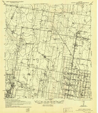 1940 Monte Christo1940 Print · USGSHidalgo County ranching and irrigation systems are shown here in the 1930s and 40s as a structured agricultural grid takes shape. Researchers can trace family homesteads like Tanquecillas Ranch or locate the site of the Wimobasis Club and early railroad stops on the St L B & M Ry.2 unique versions available
 - 1949 Map of Mc Allen, 1954 Print
 1949 Mc Allen1954 Print · USGSThe Rio Grande Valley at mid-century reveals a bustling international corridor of citrus groves, rail lines, and growing border towns. Genealogists and historians can trace the Missouri Pacific RR through McAllen or locate rural landmarks like the Santa Fe School and Arkansas City.
End of results
Showing maps 1-2 of 2
Top cities near Monte Christo
- McAllen historical maps
- Edinburg historical maps
- Mission historical maps
- Pharr historical maps
- San Juan historical maps
- Alamo historical maps
See more
Frequently asked questions
- What are the different types of historical maps available for Monte Christo?
- What is the oldest map of Monte Christo?
- Where can I purchase historical maps of Monte Christo for my home or office?
- Where can I download high-res historical maps of Monte Christo?
- Are there historical topographic maps available for Monte Christo?
- Is there historical aerial imagery available for Monte Christo?
- Where are historical maps of Monte Christo sourced from?