1960s Maps of Antelope, Texas
Explore 2 historic maps of Antelope from the 1960s. These maps offer a rare glimpse into what life looked like during the 1960s — showing old roads, neighborhoods, homes, and landmarks that have changed or disappeared over time.
Whether you're researching your family's past, planning a metal detecting trip, or studying how Antelope's landscape evolved across the 1960s, these high-resolution maps are a powerful tool for exploring the history of this region.
- Focus on a specific era: All maps on this page are from the 1960s, giving you a focused view of this time period.
- See what’s changed: Compare century-old streets, trails, and buildings to today's modern landscape using overlays and satellite layers.
- Research with precision: Use these maps for genealogy, historical research, land use analysis, or educational projects.
- View, download, or print: Maps are fully viewable online in high resolution, and can be downloaded or printed for your own records.
Start exploring Antelope's history through authentic maps from the 1960s. This is your window into the past.
Antelope, TX maps
(2)- 1962 Map of Antelope Creek NE, 1982 Print
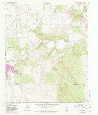 1962 Antelope Creek NE1982 Print · USGSThis North Central Texas landscape on the Baylor and Throckmorton county line captures the region's mid-century petroleum and water development. Researchers can trace the expansion of the Millers Creek Reservoir and identify early Oil Wells along Marys Creek.
 - 1964 Map of Antelope, 1967 Print
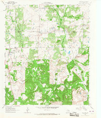 1964 Antelope1967 Print · USGSThe community of Antelope and the surrounding North Texas ranchlands are captured here in the early sixties as the local petroleum industry expanded. Researchers can trace family sites near McKinlay and Shannon, or locate the Antelope Cem along the West Fork Trinity River.2 unique versions available
End of results
Showing maps 1-2 of 2
Top cities near Antelope
Frequently asked questions
- What are the different types of historical maps available for Antelope?
- What is the oldest map of Antelope?
- Where can I purchase historical maps of Antelope for my home or office?
- Where can I download high-res historical maps of Antelope?
- Are there historical topographic maps available for Antelope?
- Is there historical aerial imagery available for Antelope?
- Where are historical maps of Antelope sourced from?