1970s Maps of Lamb County, Texas
Explore 4 historic maps of Lamb County from the 1970s. These maps offer a rare glimpse into what life looked like during the 1970s — showing old roads, neighborhoods, homes, and landmarks that have changed or disappeared over time.
Whether you're researching your family's past, planning a metal detecting trip, or studying how Lamb County's landscape evolved across the 1970s, these high-resolution maps are a powerful tool for exploring the history of this region.
- Focus on a specific era: All maps on this page are from the 1970s, giving you a focused view of this time period.
- See what’s changed: Compare century-old streets, trails, and buildings to today's modern landscape using overlays and satellite layers.
- Research with precision: Use these maps for genealogy, historical research, land use analysis, or educational projects.
- View, download, or print: Maps are fully viewable online in high resolution, and can be downloaded or printed for your own records.
Start exploring Lamb County's history through authentic maps from the 1970s. This is your window into the past.
Lamb County, TX maps
(4)- 1976 Map of Anton SW, 1978 Print
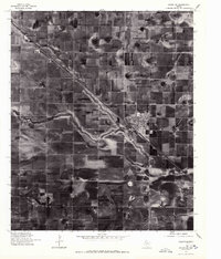 1976 Anton SW1978 Print · USGSThe High Plains of West Texas are shown in the mid-1970s, characterized by vast agricultural grids and unique playa lake formations. Genealogists and local historians can trace the development of Anton and the smaller site at Bainer along the primary transportation corridor.
 - 1976 Map of Anton NW, 1978 Print
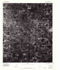 1976 Anton NW1978 Print · USGSLamb County in the mid-1970s is seen here through high-resolution aerial imagery, revealing the geometric precision of the High Plains. Researchers can trace the exact layout of Spade and the emergence of center-pivot irrigation patterns across the Texas soil.
 - 1976 Map of Anton SE, 1978 Print
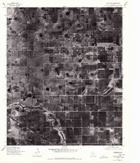 1976 Anton SE1978 Print · USGSThe Lubbock plains in the mid-1970s show a highly organized landscape of industrial agriculture and rural roads. Historians and researchers can locate the settlement of Roundup and trace the administrative COUNTY LINE through the meticulously gridded farmsteads.2 unique versions available
 - 1976 Map of Anton NE, 1978 Print
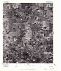 1976 Anton NE1978 Print · USGSThe Texas High Plains appear in clear aerial detail during the mid-1970s, showing a landscape transformed by intensive irrigation and ranching. Researchers can trace the meandering course of Blackwater Draw through a complex grid of rural homesteads and circular field patterns.2 unique versions available
End of results
Showing maps 1-4 of 4
Top cities of Lamb County
- Littlefield historical maps
- Olton historical maps
- Earth historical maps
- Sudan historical maps
- Amherst historical maps
- Springlake historical maps
Frequently asked questions
- What are the different types of historical maps available for Lamb County?
- What is the oldest map of Lamb County?
- Where can I purchase historical maps of Lamb County for my home or office?
- Where can I download high-res historical maps of Lamb County?
- Are there historical topographic maps available for Lamb County?
- Is there historical aerial imagery available for Lamb County?
- Where are historical maps of Lamb County sourced from?