1960s Maps of Marquez, Texas
Explore 3 historic maps of Marquez from the 1960s. These maps offer a rare glimpse into what life looked like during the 1960s — showing old roads, neighborhoods, homes, and landmarks that have changed or disappeared over time.
Whether you're researching your family's past, planning a metal detecting trip, or studying how Marquez's landscape evolved across the 1960s, these high-resolution maps are a powerful tool for exploring the history of this region.
- Focus on a specific era: All maps on this page are from the 1960s, giving you a focused view of this time period.
- See what’s changed: Compare century-old streets, trails, and buildings to today's modern landscape using overlays and satellite layers.
- Research with precision: Use these maps for genealogy, historical research, land use analysis, or educational projects.
- View, download, or print: Maps are fully viewable online in high resolution, and can be downloaded or printed for your own records.
Start exploring Marquez's history through authentic maps from the 1960s. This is your window into the past.
Marquez, TX maps
(3)- 1964 Map of Margie, 1967 Print
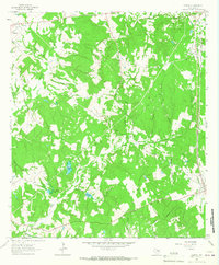 1964 Margie1967 Print · USGSLeon County in the mid-1960s shows a landscape of rail-dependent settlements and rural churches. Genealogists can trace family names through Greer Cem and White Cem, or locate the Old Bowlin Ch near the active rail lines.2 unique versions available
 - 1965 Map of Marquez, 1967 Print
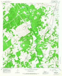 1965 Marquez1967 Print · USGSLeon and Robertson counties are captured here in the mid-sixties, dominated by the winding path of the NAVASOTA RIVER. Genealogists can trace rural communities like Venetia and locate several burial sites including Holly Cem and Kaster Cem.2 unique versions available
 - 1966 Map of Round Prairie, 1968 Print
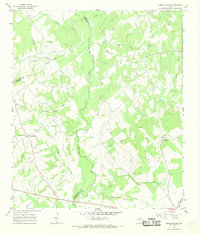 1966 Round Prairie1968 Print · USGSThe tri-county borderlands of Leon, Limestone, and Robertson counties are captured here in the mid-1960s. Genealogists can trace family heritage through numerous burial sites like Seale-Round Prairie Cem and Grayson Cem near the Navasota River.3 unique versions available
End of results
Showing maps 1-3 of 3
Top cities near Marquez
Frequently asked questions
- What are the different types of historical maps available for Marquez?
- What is the oldest map of Marquez?
- Where can I purchase historical maps of Marquez for my home or office?
- Where can I download high-res historical maps of Marquez?
- Are there historical topographic maps available for Marquez?
- Is there historical aerial imagery available for Marquez?
- Where are historical maps of Marquez sourced from?