1900s (20th Century) Maps of Cleveland, Texas
Explore 9 historic maps of Cleveland from the 1900s (20th Century). These maps offer a rare glimpse into what life looked like during the 1900s — showing old roads, neighborhoods, homes, and landmarks that have changed or disappeared over time.
Whether you're researching your family's past, planning a metal detecting trip, or studying how Cleveland's landscape evolved across the 1900s, these high-resolution maps are a powerful tool for exploring the history of this region.
- Focus on a specific era: All maps on this page are from the 1900s, giving you a focused view of this time period.
- See what’s changed: Compare century-old streets, trails, and buildings to today's modern landscape using overlays and satellite layers.
- Research with precision: Use these maps for genealogy, historical research, land use analysis, or educational projects.
- View, download, or print: Maps are fully viewable online in high resolution, and can be downloaded or printed for your own records.
Start exploring Cleveland's history through authentic maps from the 1900s. This is your window into the past.
Cleveland, TX maps
(9)- 1954 Map of Beaumont, 1964 Print
 1954 Beaumont1964 Print · USGSSoutheast Texas in the mid-fifties reveals a landscape of massive national forests, emerging reservoirs, and a booming oil economy. Genealogists and researchers can trace rural settlements like Dallardsville and Village Mills or locate early drilling sites at Sour Lake Oil Field.3 unique versions available
 - 1957 Map of Beaumont
 1957 Beaumont1957 Print · USGSSoutheast Texas in the mid-fifties is defined by the timber-rich lands between the Trinity River and Beaumont. Trace the history of the Alabama and Coushatti Indian Reservation or locate early campus sites like Prairie View College.
 - 1958 Map of Fostoria, 1959 Print
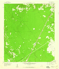
 1958 Fostoria1959 Print · USGSThe timber country of southeast Texas is captured here in the late fifties, centered on the mill town of Fostoria. Researchers can trace old family landmarks and rural life at Pin Oak Cem, Pilgrim Rest Ch, and the logging stops along the Gulf Colorado and Santa Fe railroad.3 unique versions available
 - 1958 Map of Cleveland, 1959 Print
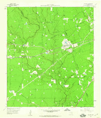
 1958 Cleveland1959 Print · USGSCleveland emerged as a bustling rail and timber crossroads in the late fifties, where major lines met at the edge of the national forest. Genealogists and historians can trace old community anchors like Pin Oak Cem, New Salem Ch, and the outlying settlement of Fostoria.2 unique versions available
 - 1958 Map of Westcott, 1959 Print
 1958 Westcott1959 Print · USGSThe Piney Woods of San Jacinto County meet the open grasslands in the late fifties, as rail lines drove the local timber economy. Researchers can locate family landmarks like Lovett Cem, the Big Creek Missionary Ch, and the rural school at Dixon High Sch.3 unique versions available
 - 1984 Map of Beaumont
 1984 Beaumont1984 Print · USGSSoutheast Texas in the late seventies and early eighties shows a landscape of expanding reservoirs and deep timber industry. Researchers can trace the development of the Sam Houston National Forest or locate regional landmarks like Grabbs Prairie and the Wynne State Prison Farm.3 unique versions available
 - 1985 Map of Conroe
 1985 Conroe1985 Print · USGSSoutheast Texas in the mid-eighties shows a landscape of timberlands and new lakeside developments. Researchers can trace the legacy of rail lines like the Southern Pacific RR or locate rural communities such as Plantersville, Yarboro, and Hufsmith.2 unique versions available
 - 1997 Map of Cleveland, 2000 Print
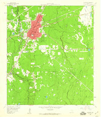
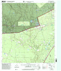
 1997 Cleveland2000 Print · USGSIn the late 1990s, Cleveland and its surrounding oil fields were a nexus of industry and community at the edge of the Piney Woods. Genealogists and researchers can trace family roots through several landmarks including Pin Oak Cemetery, New Salem Church, and the outlying settlement of Fostoria.
 - 1997 Map of Fostoria, 2000 Print
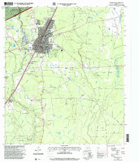
 1997 Fostoria2000 Print · USGSThe Montgomery and San Jacinto county lines converged in the late 1990s within the timberlands of the Sam Houston National Forest. Researchers can trace rural family sites and local landmarks like Security Cemetery, Morgan Cemetery, and the settlement of Fostoria.
End of results
Showing maps 1-9 of 9
Top cities near Cleveland
- Dayton historical maps
- Roman Forest historical maps
- Shepherd historical maps
- Splendora historical maps
- Patton Village historical maps
- Woodbranch historical maps
See more
Top neighborhoods of Cleveland
Frequently asked questions
- What are the different types of historical maps available for Cleveland?
- What is the oldest map of Cleveland?
- Where can I purchase historical maps of Cleveland for my home or office?
- Where can I download high-res historical maps of Cleveland?
- Are there historical topographic maps available for Cleveland?
- Is there historical aerial imagery available for Cleveland?
- Where are historical maps of Cleveland sourced from?