1900s (20th Century) Maps of Mart, Texas
Explore 5 historic maps of Mart from the 1900s (20th Century). These maps offer a rare glimpse into what life looked like during the 1900s — showing old roads, neighborhoods, homes, and landmarks that have changed or disappeared over time.
Whether you're researching your family's past, planning a metal detecting trip, or studying how Mart's landscape evolved across the 1900s, these high-resolution maps are a powerful tool for exploring the history of this region.
- Focus on a specific era: All maps on this page are from the 1900s, giving you a focused view of this time period.
- See what’s changed: Compare century-old streets, trails, and buildings to today's modern landscape using overlays and satellite layers.
- Research with precision: Use these maps for genealogy, historical research, land use analysis, or educational projects.
- View, download, or print: Maps are fully viewable online in high resolution, and can be downloaded or printed for your own records.
Start exploring Mart's history through authentic maps from the 1900s. This is your window into the past.
Mart, TX maps
(5)- 1920 Map of Mart
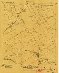 1920 Mart1920 Print · USGSCentral Texas at the dawn of the 1920s shows a landscape of busy rail junctions and small post office hubs. Researchers can trace rural lineages through William's School, the community at Axtell P.O., and the Navasota River bottomlands.
 - 1954 Map of Waco, 1964 Print
 1954 Waco1964 Print · USGSCentral Texas during the mid-fifties shows a landscape defined by the expansion of Fort Hood Military Reservation and the Brazos river system. Trace the rail lines and early airfields like James Connally Air Force Base and settlements like Temple or McGregor.2 unique versions available
 - 1955 Map of Waco
 1955 Waco1955 Print · USGSCentral Texas at the peak of the Cold War reveals a landscape defined by military expansion and major water projects. Researchers can trace the footprints of Fort Hood, the waters of Lake Waco, and regional hubs like Temple or Mexia.
 - 1956 Map of Mart, 1958 Print
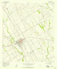 1956 Mart1958 Print · USGSAgricultural life in McLennan County thrived in the mid-1950s as the town of Mart sat at the busy intersection of the Missouri Pacific rail line. Researchers can trace rural school locations like Anderson Sch and family burial sites at Evergreen Cem and Mart Cem.2 unique versions available
 - 1985 Map of Mexia
 1985 Mexia1985 Print · USGSLimestone and Freestone counties are shown in the mid-eighties as centers of rail-linked commerce and growing reservoir systems. Researchers can trace the grounds of Mexia State School, the campus of Westminster College, and historic Fort Parker.2 unique versions available
End of results
Showing maps 1-5 of 5
Top cities near Mart
- Waco historical maps
- Marlin historical maps
- Riesel historical maps
- Coolidge historical maps
- Kosse historical maps
- Hallsburg historical maps
See more
Frequently asked questions
- What are the different types of historical maps available for Mart?
- What is the oldest map of Mart?
- Where can I purchase historical maps of Mart for my home or office?
- Where can I download high-res historical maps of Mart?
- Are there historical topographic maps available for Mart?
- Is there historical aerial imagery available for Mart?
- Where are historical maps of Mart sourced from?