1950s Maps of McGregor, Texas
Explore 5 historic maps of McGregor from the 1950s. These maps offer a rare glimpse into what life looked like during the 1950s — showing old roads, neighborhoods, homes, and landmarks that have changed or disappeared over time.
Whether you're researching your family's past, planning a metal detecting trip, or studying how McGregor's landscape evolved across the 1950s, these high-resolution maps are a powerful tool for exploring the history of this region.
- Focus on a specific era: All maps on this page are from the 1950s, giving you a focused view of this time period.
- See what’s changed: Compare century-old streets, trails, and buildings to today's modern landscape using overlays and satellite layers.
- Research with precision: Use these maps for genealogy, historical research, land use analysis, or educational projects.
- View, download, or print: Maps are fully viewable online in high resolution, and can be downloaded or printed for your own records.
Start exploring McGregor's history through authentic maps from the 1950s. This is your window into the past.
McGregor, TX maps
(5)- 1950 Map of Gatesville, 1953 Print
 1950 Gatesville1953 Print · USGSCoryell County is captured here in the mid-twentieth century, showing the growing overlap between civilian life and the military footprint at North Fort Hood. Researchers can trace rural lineages through sites like Mound Cem, Leon Junction Sch, and the long-established State Reform School.
 - 1954 Map of Waco, 1964 Print
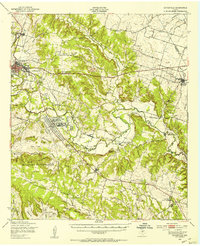
 1954 Waco1964 Print · USGSCentral Texas during the mid-fifties shows a landscape defined by the expansion of Fort Hood Military Reservation and the Brazos river system. Trace the rail lines and early airfields like James Connally Air Force Base and settlements like Temple or McGregor.2 unique versions available
 - 1955 Map of Waco
 1955 Waco1955 Print · USGSCentral Texas at the peak of the Cold War reveals a landscape defined by military expansion and major water projects. Researchers can trace the footprints of Fort Hood, the waters of Lake Waco, and regional hubs like Temple or Mexia.
 - 1957 Map of Oglesby, 1961 Print
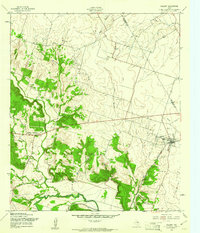 1957 Oglesby1961 Print · USGSSettlement in the late fifties centers on the railroad town of Oglesby and the winding Leon River. Genealogists and researchers can trace family landmarks like Pecan Grove Ch, Lamb Cem, and the mid-century Midway Drag Strip.2 unique versions available
 - 1958 Map of Gatesville, 1962 Print
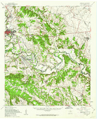 1958 Gatesville1962 Print · USGSCoryell County during the late fifties reveals the expanding footprint of the army alongside traditional river-valley settlements. Genealogists can trace family landmarks like Friendship Cemetery, the Gatesville State School for Boys, and the rail stops of the St Louis Southwestern Railroad.2 unique versions available
End of results
Showing maps 1-5 of 5
Top cities near McGregor
- Waco historical maps
- Hewitt historical maps
- Robinson historical maps
- Woodway historical maps
- Troy historical maps
- Lorena historical maps
See more
Frequently asked questions
- What are the different types of historical maps available for McGregor?
- What is the oldest map of McGregor?
- Where can I purchase historical maps of McGregor for my home or office?
- Where can I download high-res historical maps of McGregor?
- Are there historical topographic maps available for McGregor?
- Is there historical aerial imagery available for McGregor?
- Where are historical maps of McGregor sourced from?