1970s Maps of Hondo, Texas
Explore 2 historic maps of Hondo from the 1970s. These maps offer a rare glimpse into what life looked like during the 1970s — showing old roads, neighborhoods, homes, and landmarks that have changed or disappeared over time.
Whether you're researching your family's past, planning a metal detecting trip, or studying how Hondo's landscape evolved across the 1970s, these high-resolution maps are a powerful tool for exploring the history of this region.
- Focus on a specific era: All maps on this page are from the 1970s, giving you a focused view of this time period.
- See what’s changed: Compare century-old streets, trails, and buildings to today's modern landscape using overlays and satellite layers.
- Research with precision: Use these maps for genealogy, historical research, land use analysis, or educational projects.
- View, download, or print: Maps are fully viewable online in high resolution, and can be downloaded or printed for your own records.
Start exploring Hondo's history through authentic maps from the 1970s. This is your window into the past.
Hondo, TX maps
(2)- 1970 Map of Murphy School, 1973 Print
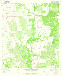 1970 Murphy School1973 Print · USGSMedina County rural life in the late sixties is centered on the drainage of Hondo Creek and the Southern Pacific line. Genealogists and historians can locate the Murphy Sch, a local Cem, and numerous Oil Wells across the landscape.2 unique versions available
 - 1970 Map of Hondo, 1973 Print
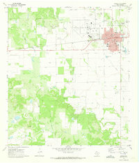 1970 Hondo1973 Print · USGSHondo sits at a crossroads of rail and air travel in the early 1970s, as the community expanded around the Southern Pacific tracks. Researchers can trace local lineage through St John Sch and Cottonwood Cem, or locate the historic Municipal Airport.2 unique versions available
End of results
Showing maps 1-2 of 2
Top cities near Hondo
Frequently asked questions
- What are the different types of historical maps available for Hondo?
- What is the oldest map of Hondo?
- Where can I purchase historical maps of Hondo for my home or office?
- Where can I download high-res historical maps of Hondo?
- Are there historical topographic maps available for Hondo?
- Is there historical aerial imagery available for Hondo?
- Where are historical maps of Hondo sourced from?