1960s Maps of Menard County, Texas
Explore 4 historic maps of Menard County from the 1960s. These maps offer a rare glimpse into what life looked like during the 1960s — showing old roads, neighborhoods, homes, and landmarks that have changed or disappeared over time.
Whether you're researching your family's past, planning a metal detecting trip, or studying how Menard County's landscape evolved across the 1960s, these high-resolution maps are a powerful tool for exploring the history of this region.
- Focus on a specific era: All maps on this page are from the 1960s, giving you a focused view of this time period.
- See what’s changed: Compare century-old streets, trails, and buildings to today's modern landscape using overlays and satellite layers.
- Research with precision: Use these maps for genealogy, historical research, land use analysis, or educational projects.
- View, download, or print: Maps are fully viewable online in high resolution, and can be downloaded or printed for your own records.
Start exploring Menard County's history through authentic maps from the 1960s. This is your window into the past.
Menard County, TX maps
(4)- 1963 Map of McKegan Draw NE, 1966 Print
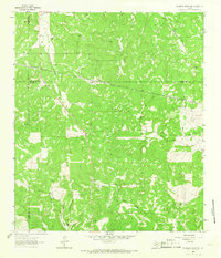 1963 McKegan Draw NE1966 Print · USGSThe ranchlands at the intersection of Kimble and Menard Counties are captured here in the early sixties. Researchers can trace family legacies at the Lehne Ranch, Graham Ranch, and Johnston Ranch, or locate the Murr Ch at the edge of the creek draws.2 unique versions available
 - 1965 Map of San Angelo
 1965 San Angelo1965 Print · USGSWest Texas in the mid-sixties reveals a landscape shaped by the petroleum industry and strategic water management. Genealogists and historians can trace the rail corridor through Texon and Big Lake, or locate military landmarks like Goodfellow AFB and Broome Air Force Auxiliary Airfield.
 - 1968 Map of Sheep Run Creek, 1971 Print
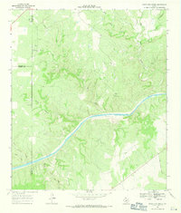 1968 Sheep Run Creek1971 Print · USGSThe Texas Hill Country landscape near the Llano River is captured in the late sixties, showing the convergence of Mason, Menard, and Kimble counties. Trace the paths of Leon Creek and Sheep Run or locate landmarks like Hogg Bluff and James River Road.2 unique versions available
 - 1968 Map of London, 1971 Print
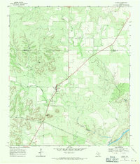 1968 London1971 Print · USGSLondon sits at the heart of this late-sixties Kimble County survey, where the Hill Country terrain meets the local ranching economy. Researchers can locate the London Cem and the prominent Reichenau Gap, or trace the path of the Llano River.
End of results
Showing maps 1-4 of 4
Top cities of Menard County
Frequently asked questions
- What are the different types of historical maps available for Menard County?
- What is the oldest map of Menard County?
- Where can I purchase historical maps of Menard County for my home or office?
- Where can I download high-res historical maps of Menard County?
- Are there historical topographic maps available for Menard County?
- Is there historical aerial imagery available for Menard County?
- Where are historical maps of Menard County sourced from?