1960s Maps of Downtown Midland Management District, Midland
Explore 2 historic maps of Downtown Midland Management District from the 1960s. These maps offer a rare glimpse into what life looked like during the 1960s — showing old roads, neighborhoods, homes, and landmarks that have changed or disappeared over time.
Whether you're researching your family's past, planning a metal detecting trip, or studying how Downtown Midland Management District's landscape evolved across the 1960s, these high-resolution maps are a powerful tool for exploring the history of this region.
- Focus on a specific era: All maps on this page are from the 1960s, giving you a focused view of this time period.
- See what’s changed: Compare century-old streets, trails, and buildings to today's modern landscape using overlays and satellite layers.
- Research with precision: Use these maps for genealogy, historical research, land use analysis, or educational projects.
- View, download, or print: Maps are fully viewable online in high resolution, and can be downloaded or printed for your own records.
Start exploring Downtown Midland Management District's history through authentic maps from the 1960s. This is your window into the past.
Downtown Midland Management District, Midland maps
(2)- 1965 Map of Southeast Midland, 1966 Print
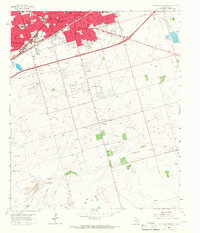 1965 Southeast Midland1966 Print · USGSMidland during the mid-sixties mid-century boom shows a rapidly expanding urban grid meeting the rural plains. Genealogists and local historians can trace neighborhood growth through Sandy Acres, locate the Cotton Flat Ch, or find vanished landmarks like the local Raceway.3 unique versions available
 - 1965 Map of Northeast Midland, 1968 Print
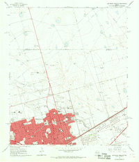 1965 Northeast Midland1968 Print · USGSMid-century Midland is shown during its oil-fueled expansion, where a dense street grid meets the high plains. Researchers can trace family history through neighborhood schools like Fannin Sch or visit the Fairview Cemetery and County Fairground.2 unique versions available
End of results
Showing maps 1-2 of 2
Frequently asked questions
- What are the different types of historical maps available for Downtown Midland Management District?
- What is the oldest map of Downtown Midland Management District?
- Where can I purchase historical maps of Downtown Midland Management District for my home or office?
- Where can I download high-res historical maps of Downtown Midland Management District?
- Are there historical topographic maps available for Downtown Midland Management District?
- Is there historical aerial imagery available for Downtown Midland Management District?
- Where are historical maps of Downtown Midland Management District sourced from?