1980s Maps of Ratler, Texas
Explore 2 historic maps of Ratler from the 1980s. These maps offer a rare glimpse into what life looked like during the 1980s — showing old roads, neighborhoods, homes, and landmarks that have changed or disappeared over time.
Whether you're researching your family's past, planning a metal detecting trip, or studying how Ratler's landscape evolved across the 1980s, these high-resolution maps are a powerful tool for exploring the history of this region.
- Focus on a specific era: All maps on this page are from the 1980s, giving you a focused view of this time period.
- See what’s changed: Compare century-old streets, trails, and buildings to today's modern landscape using overlays and satellite layers.
- Research with precision: Use these maps for genealogy, historical research, land use analysis, or educational projects.
- View, download, or print: Maps are fully viewable online in high resolution, and can be downloaded or printed for your own records.
Start exploring Ratler's history through authentic maps from the 1980s. This is your window into the past.
Ratler, TX maps
(2)- 1980 Map of Regency
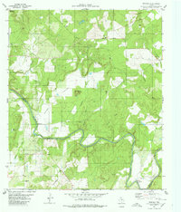 1980 Regency1980 Print · USGSThe Colorado River marks the county line in this central Texas landscape during the late seventies. Researchers can locate rural landmarks like Regency, the Ridge Community Hall, and family sites at Hollis Cem or Mesquite Cem.
 - 1985 Map of San Saba
 1985 San Saba1985 Print · USGSCentral Texas in the mid-eighties was a landscape of river-valley ranching and quiet railroad towns. Researchers can trace family history through sites like San Saba Cem, follow the Atchison Topeka and Santa Fe line, or explore landmarks near Pecan Bayou.2 unique versions available
End of results
Showing maps 1-2 of 2
Top cities near Ratler
- San Saba historical maps
- Goldthwaite historical maps
- Richland Springs historical maps
- Mullin historical maps
Frequently asked questions
- What are the different types of historical maps available for Ratler?
- What is the oldest map of Ratler?
- Where can I purchase historical maps of Ratler for my home or office?
- Where can I download high-res historical maps of Ratler?
- Are there historical topographic maps available for Ratler?
- Is there historical aerial imagery available for Ratler?
- Where are historical maps of Ratler sourced from?