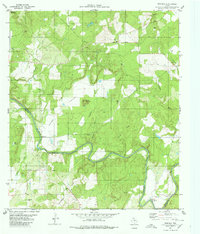
1980 Map of Regency
USGS Topo · Published 1980About this map
The Colorado River carves a winding path through this portion of central Texas, serving as the natural boundary between Mills Co and San Saba Co. The landscape is defined by its dramatic relief, where the broad floor of Hanna Valley is overlooked by prominent elevations like Hanna Mountain and Round Mountain. In 1980, this area remained largely rural, centered around the small settlement of Regency and the Ridge Community Hall to the north. Smaller communities and landmarks like Ratler in the south and the Hollis Cem provide essential anchor points for genealogists researching family ties in the region. Numerous creeks including Flatrock Creek, Hog Creek, and Mesquite Creek feed into the river, while several Gravel Pits indicate the local extractive activity that shaped the terrain during this era.
Find a feature on this map
27 named features on this map. Tap any name to fly to it.
Don’t see what you’re looking for? This feature index may not catch every label — zoom into the map to look around manually.
Map Details
Editions of this 1980 Regency Map
This is the sole edition of this map. No revisions or reprints were ever made.
Other maps of this area

1885 · San Saba
USGS Topo · 1:125,000

1889 · Brownwood
USGS Topo · 1:125,000

1894 · Brownwood
USGS Topo · 1:125,000

1894 · San Saba
USGS Topo · 1:125,000

1925 · San Saba 2-a
USGS Topo · 1:48,000

1925 · Brownwood 3-d
USGS Topo · 1:48,000

1925 · San Saba 1-c
USGS Topo · 1:48,000

1925 · San Saba 1-b
USGS Topo · 1:48,000

1925 · San Saba 2-b
USGS Topo · 1:48,000

1925 · Brownwood 4-c
USGS Topo · 1:48,000