1990s Maps of Conroe, Texas
Explore 3 historic maps of Conroe from the 1990s. These maps offer a rare glimpse into what life looked like during the 1990s — showing old roads, neighborhoods, homes, and landmarks that have changed or disappeared over time.
Whether you're researching your family's past, planning a metal detecting trip, or studying how Conroe's landscape evolved across the 1990s, these high-resolution maps are a powerful tool for exploring the history of this region.
- Focus on a specific era: All maps on this page are from the 1990s, giving you a focused view of this time period.
- See what’s changed: Compare century-old streets, trails, and buildings to today's modern landscape using overlays and satellite layers.
- Research with precision: Use these maps for genealogy, historical research, land use analysis, or educational projects.
- View, download, or print: Maps are fully viewable online in high resolution, and can be downloaded or printed for your own records.
Start exploring Conroe's history through authentic maps from the 1990s. This is your window into the past.
Conroe, TX maps
(3)- 1997 Map of Montgomery, 2000 Print
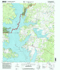
 1997 Montgomery2000 Print · USGSThe historic county seat of Montgomery and the sprawling shores of Lake Conroe are captured here in the late nineties. Local researchers can trace family roots through landmarks like China Chapel, Lincoln Sch, and the Montgomery Cemetery.
 - 1997 Map of Willis, 2000 Print
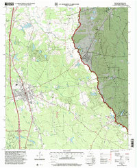 1997 Willis2000 Print · USGSWillis and the surrounding Montgomery County piney woods are captured here in the late nineties as the town expanded near the national forest. Genealogists and local historians can locate the New Hope Church, Turner High School, and the industrial footprint of the Pitts Gas Field.
 - 1997 Map of Shepard Hill, 2000 Print
 1997 Shepard Hill2000 Print · USGSThe woodlands and shorelines of Montgomery County appear in detail during the late nineties as recreation and reservoir management shaped the landscape. Researchers can locate Shepard Cemetery and trace the complex waterways of Peach Creek and Lewis Creek Reservoir.
End of results
Showing maps 1-3 of 3
Top cities near Conroe
- Houston historical maps
- The Woodlands historical maps
- Tomball historical maps
- Willis historical maps
- Oak Ridge North historical maps
- Panorama Village historical maps
See more
Top neighborhoods of Conroe
- Woodland Hills historical maps
- Stillwater Community historical maps
- Beach historical maps
- The Regency historical maps
- Windsor Lakes historical maps
- Mansions Villas historical maps
See more
Frequently asked questions
- What are the different types of historical maps available for Conroe?
- What is the oldest map of Conroe?
- Where can I purchase historical maps of Conroe for my home or office?
- Where can I download high-res historical maps of Conroe?
- Are there historical topographic maps available for Conroe?
- Is there historical aerial imagery available for Conroe?
- Where are historical maps of Conroe sourced from?