1960s Maps of Conroe, Texas
Explore 4 historic maps of Conroe from the 1960s. These maps offer a rare glimpse into what life looked like during the 1960s — showing old roads, neighborhoods, homes, and landmarks that have changed or disappeared over time.
Whether you're researching your family's past, planning a metal detecting trip, or studying how Conroe's landscape evolved across the 1960s, these high-resolution maps are a powerful tool for exploring the history of this region.
- Focus on a specific era: All maps on this page are from the 1960s, giving you a focused view of this time period.
- See what’s changed: Compare century-old streets, trails, and buildings to today's modern landscape using overlays and satellite layers.
- Research with precision: Use these maps for genealogy, historical research, land use analysis, or educational projects.
- View, download, or print: Maps are fully viewable online in high resolution, and can be downloaded or printed for your own records.
Start exploring Conroe's history through authentic maps from the 1960s. This is your window into the past.
Conroe, TX maps
(4)- 1960 Map of Willis, 1961 Print
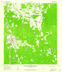 1960 Willis1961 Print · USGSThe town of Willis stands at the edge of the East Texas timberlands in the early sixties, a landscape defined by forest and resource extraction. Researchers can locate family landmarks such as New Hope Ch, the Turner High Sch, and the Missouri Pacific rail line.3 unique versions available
 - 1961 Map of Tamina, 1962 Print
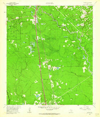 1961 Tamina1962 Print · USGSSouthern Montgomery County in the early sixties is a landscape of timber and oil, dominated by the West Fork San Jacinto River. Researchers can trace the roots of local communities at Tamina, locate family plots in the Tamina Cem, and explore the rail-side growth near Rayford.4 unique versions available
 - 1962 Map of Keenan, 1963 Print
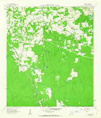 1962 Keenan1963 Print · USGSMontgomery County was a landscape of timber and rail in the early sixties, defined by the winding course of Lake Creek. Researchers can locate several family burial grounds, including Keenan Cem and Collier Cem, alongside the Spring Tabernacle church.3 unique versions available
 - 1962 Map of Oklahoma, 1963 Print
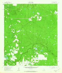 1962 Oklahoma1963 Print · USGSSoutheast Texas in the early sixties was a landscape of expanding oil fields and small rural settlements. Genealogists and historians can trace the foundations of Oklahoma and Egypt, locate the Zion Cem, and follow the Missouri Pacific rail line.4 unique versions available
End of results
Showing maps 1-4 of 4
Top cities near Conroe
- Houston historical maps
- The Woodlands historical maps
- Tomball historical maps
- Willis historical maps
- Oak Ridge North historical maps
- Panorama Village historical maps
See more
Top neighborhoods of Conroe
- Woodland Hills historical maps
- Stillwater Community historical maps
- Beach historical maps
- The Regency historical maps
- Windsor Lakes historical maps
- Mansions Villas historical maps
See more
Frequently asked questions
- What are the different types of historical maps available for Conroe?
- What is the oldest map of Conroe?
- Where can I purchase historical maps of Conroe for my home or office?
- Where can I download high-res historical maps of Conroe?
- Are there historical topographic maps available for Conroe?
- Is there historical aerial imagery available for Conroe?
- Where are historical maps of Conroe sourced from?