1960s Maps of Indigo Ranch, Montgomery County
Explore 2 historic maps of Indigo Ranch from the 1960s. These maps offer a rare glimpse into what life looked like during the 1960s — showing old roads, neighborhoods, homes, and landmarks that have changed or disappeared over time.
Whether you're researching your family's past, planning a metal detecting trip, or studying how Indigo Ranch's landscape evolved across the 1960s, these high-resolution maps are a powerful tool for exploring the history of this region.
- Focus on a specific era: All maps on this page are from the 1960s, giving you a focused view of this time period.
- See what’s changed: Compare century-old streets, trails, and buildings to today's modern landscape using overlays and satellite layers.
- Research with precision: Use these maps for genealogy, historical research, land use analysis, or educational projects.
- View, download, or print: Maps are fully viewable online in high resolution, and can be downloaded or printed for your own records.
Start exploring Indigo Ranch's history through authentic maps from the 1960s. This is your window into the past.
Indigo Ranch, Montgomery County maps
(2)- 1962 Map of Magnolia East, 1964 Print
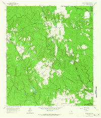 1962 Magnolia East1964 Print · USGSSoutheast Texas at the start of the sixties reveals a landscape shaped by rail lines and the growing oil industry. Researchers can trace family roots at Decker Prairie Cem or locate rural landmarks like Mt Zion Ch and the Cycling Plant.2 unique versions available
 - 1962 Map of Magnolia West, 1964 Print
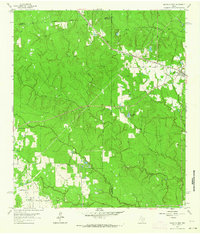 1962 Magnolia West1964 Print · USGSSoutheast Texas in the early sixties remains a landscape of timber and creek bottoms where county lines meet. Genealogists and historians can trace family locations near the Old Sanders Cem, the community of Fetzer, and the Lookout Tower Magnolia.3 unique versions available
End of results
Showing maps 1-2 of 2
Frequently asked questions
- What are the different types of historical maps available for Indigo Ranch?
- What is the oldest map of Indigo Ranch?
- Where can I purchase historical maps of Indigo Ranch for my home or office?
- Where can I download high-res historical maps of Indigo Ranch?
- Are there historical topographic maps available for Indigo Ranch?
- Is there historical aerial imagery available for Indigo Ranch?
- Where are historical maps of Indigo Ranch sourced from?