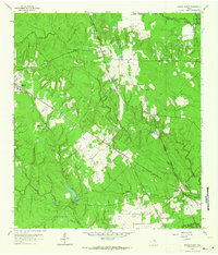
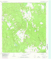
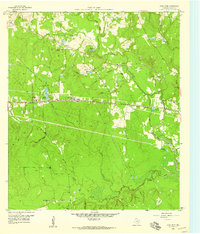
1962 Map of Magnolia East
USGS Topo · Published 1964About this map
The Missouri Pacific and Chicago Rock Island and Pacific railroads intersect in this corner of the Texas Piney Woods, anchoring small settlements like Mostyn and Karen. The landscape is a transition between timbered creeks and open clearings like Ellis Prairie, marked by a developing mid-century energy infrastructure. The presence of the Decker Prairie Oil Field and a Cycling Plant indicate the region's industrial shift, while numerous rural institutions preserve an older social fabric.
Find a feature on this map
40 named features on this map. Tap any name to fly to it.
Don’t see what you’re looking for? This feature index may not catch every label — zoom into the map to look around manually.
Map Details
Editions of this 1962 Magnolia East Map
2 editions found
Other maps of this area

1916 · Rose Hill
USGS Topo · 1:24,000

1916 · Louetta
USGS Topo · 1:24,000

1916 · Hockley
USGS Topo · 1:24,000
1920 · Hockley
USGS Topo · 1:31,680

1920 · Rose Hill
USGS Topo · 1:31,680
1920 · Louetta
USGS Topo · 1:31,680

1954 · Beaumont
USGS Topo · 1:250,000

1957 · Beaumont
USGS Topo · 1:250,000
1958 · Cowl Spur
USGS Topo · 1:24,000
1962 · Keenan
USGS Topo · 1:24,000