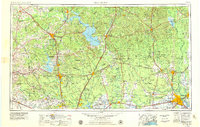
1957 Map of Beaumont
USGS Topo · Published 1957About this map
The Alabama and Coushatti Indian Reservation lies at the heart of this East Texas survey, surrounded by the dense woodlands of the Sam Houston National Forest. The landscape is defined by the winding courses of the Trinity River and the Neches River, which supported the timber and early transport networks of the region. As the mid-century economy developed, established rail lines like the Southern Pacific and Santa Fe connected growing hubs such as Beaumont and Huntsville to smaller lumber and trade outposts.
Find a feature on this map
56 named features on this map. Tap any name to fly to it.
Don’t see what you’re looking for? This feature index may not catch every label — zoom into the map to look around manually.
Map Details
Editions of this 1957 Beaumont Map
This is the sole edition of this map. No revisions or reprints were ever made.
Historical Maps of Houston Through Time
5 maps found