
1916 Map of Satsuma
USGS Topo · Published 1916About this map
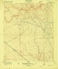
The timber industry and early rail networks define this Harris County landscape, which was surveyed just as the regional economy was diversifying beyond its piney roots. In the north, Christy Sawmill, Anderson Sawmill, and Wrothe Sawmill point to the importance of the lumber trade along the banks of Cypress Creek and Pillot Lake. Settlement is anchored by the small community at Satsuma, situated along the Houston and Texas Central railroad, while North Houston sits to the east near Greens Bayou. Early thoroughfares like Rose Hill Road and Jack Rabbit Road cut across a terrain shaped by various gullies and bayous, including Whiteoak Bayou. The presence of the Fuchs School provides a localized landmark for genealogists researching the rural families living between these early rail lines and logging operations in the years following the turn of the century.
Find a feature on this map
21 named features on this map. Tap any name to fly to it.
Don’t see what you’re looking for? This feature index may not catch every label — zoom into the map to look around manually.
Map Details
Editions of this 1916 Satsuma Map
3 editions found
Other maps of this area

1915 · Houston Heights
USGS Topo · 1:24,000

1915 · Cypress
USGS Topo · 1:24,000

1915 · Addicks
USGS Topo · 1:24,000

1915 · Hillendahl
USGS Topo · 1:24,000

1916 · Rose Hill
USGS Topo · 1:24,000

1916 · Aldine
USGS Topo · 1:24,000

1916 · Louetta
USGS Topo · 1:24,000

1916 · Spring
USGS Topo · 1:24,000

1918 · Cypress
USGS Topo · 1:31,680

1918 · Addicks
USGS Topo · 1:31,680