
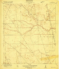
1916 Map of Aldine
USGS Topo · Published 1916About this map
Aldine stands as a primary railroad siding and settlement in Harris County during the early twentieth century, situated along the Great Northern and Galveston Line tracks. This survey, conducted in cooperation with Harris County officials including County Judge W. H. Ward, captures the transition of the Gulf Coast prairie into a structured network of agricultural tracts and early roadways. The landscape is defined by the drainage systems of Greens Bayou, Halls Bayou, and Turkey Creek, which weave through the low-elevation coastal plain. Early infrastructure is well-documented, from the Hargrove School in the northwest to established thoroughfares like Kuyendahl Road, Montgomery Road, and Erhart Road. The intricate mapping of elevations at one-foot intervals reveals the subtle topography that dictated the placement of these early Texas settlements and transit corridors before later urban expansion.
Find a feature on this map
14 named features on this map. Tap any name to fly to it.
Don’t see what you’re looking for? This feature index may not catch every label — zoom into the map to look around manually.
Map Details
Editions of this 1916 Aldine Map
2 editions found
Other maps of this area

1915 · Houston Heights
USGS Topo · 1:24,000

1915 · Hillendahl
USGS Topo · 1:24,000

1916 · Settegast
USGS Topo · 1:24,000

1916 · Louetta
USGS Topo · 1:24,000

1916 · Satsuma
USGS Topo · 1:24,000

1916 · Humble
USGS Topo · 1:24,000

1916 · Spring
USGS Topo · 1:24,000
1918 · Hillendahl
USGS Topo · 1:31,680
1919 · Aldine
USGS Topo · 1:31,680
1919 · Humble
USGS Topo · 1:31,680