
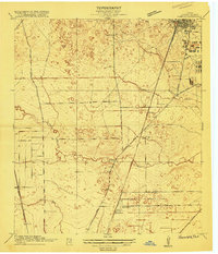
1916 Map of Humble
USGS Topo · Published 1916About this map
Humble appears as a small, developing rail town in Harris County, its early grid pattern defined by the intersection of the Houston and East Texas Road. This 1916 survey captures a landscape of low-lying prairies and wooded bottomlands, where the winding courses of Greens Bayou, Halls Bayou, and Garners Bayou dictate the placement of roads and homesteads. The surveyor’s meticulous inclusion of a one-foot contour interval highlights the extreme flatness of this Gulf Coast terrain, revealing subtle drainages and depressions that were vital to early settlers and farmers.
Find a feature on this map
20 named features on this map. Tap any name to fly to it.
Don’t see what you’re looking for? This feature index may not catch every label — zoom into the map to look around manually.
Map Details
Editions of this 1916 Humble Map
2 editions found
Other maps of this area

1915 · Houston Heights
USGS Topo · 1:24,000

1916 · Aldine
USGS Topo · 1:24,000

1916 · Settegast
USGS Topo · 1:24,000

1916 · Fauna
USGS Topo · 1:24,000

1916 · Harmaston
USGS Topo · 1:24,000

1916 · Moonshine Hill
USGS Topo · 1:24,000

1916 · Spring
USGS Topo · 1:24,000

1919 · Aldine
USGS Topo · 1:31,680

1919 · Humble
USGS Topo · 1:31,680

1919 · Weeden
USGS Topo · 1:31,680