
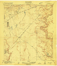
1916 Map of Harmaston
USGS Topo · Published 1916About this map
The San Jacinto River defines the eastern edge of this 1916 survey, where the winding waterway meets Big Eddy and Ingram Marsh. The landscape is a network of drainage gullies and bayous, including Greens Bayou and Garner Bayou, illustrating the low-lying hydrology of Harris County before modern flood control and urbanization. Small railroad-aligned settlements like Harmaston, Victor, and Spencer dot the route of the Beaumont Sour Lake and Western railroad, which cuts diagonally across the coastal plain.
Find a feature on this map
20 named features on this map. Tap any name to fly to it.
Don’t see what you’re looking for? This feature index may not catch every label — zoom into the map to look around manually.
Map Details
Editions of this 1916 Harmaston Map
2 editions found
Other maps of this area

1916 · Burnett Bay
USGS Topo · 1:24,000

1916 · Crosby
USGS Topo · 1:24,000

1916 · Settegast
USGS Topo · 1:24,000

1916 · Fauna
USGS Topo · 1:24,000

1916 · Moonshine Hill
USGS Topo · 1:24,000

1916 · Huffman
USGS Topo · 1:24,000

1916 · Humble
USGS Topo · 1:24,000

1919 · Humble
USGS Topo · 1:31,680

1919 · Weeden
USGS Topo · 1:31,680

1919 · Crosby
USGS Topo · 1:31,680