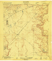
1916 Map of Harmaston
USGS Topo · Published 1916About this map
The San Jacinto River meanders through eastern Harris County in this 1916 survey, defining a landscape of low-lying wetlands and oxbow lakes. Numerous named water bodies like Silver Lake, Mud Lake, and Grassy Lake flank the river’s winding course, while Ingrando Marsh and the Big Eddy mark the complex hydrology of the coastal plain. Transport in the region is anchored by the Beaumont Sour Lake and Western railroad, which cuts a straight path across the terrain, intersecting early settlements such as Spencer, Victor, and Harmaston. The presence of the Tuskesee Ferry and the associated Tuskesee Road provides evidence of river-crossing infrastructure used by local residents before more modern bridges dominated the county. In the southwest, Dyersdale sits near the confluence of Greens Bayou, illustrating the dispersed rural settlement pattern typical of the area before the rapid expansion of Houston.
Find a feature on this map
23 named features on this map. Tap any name to fly to it.
Don’t see what you’re looking for? This feature index may not catch every label — zoom into the map to look around manually.
Map Details
Editions of this 1916 Harmaston Map
2 editions found
Other maps of this area

1916 · Burnett Bay
USGS Topo · 1:24,000

1916 · Crosby
USGS Topo · 1:24,000

1916 · Settegast
USGS Topo · 1:24,000

1916 · Fauna
USGS Topo · 1:24,000

1916 · Harmaston
USGS Topo · 1:24,000

1916 · Moonshine Hill
USGS Topo · 1:24,000

1916 · Huffman
USGS Topo · 1:24,000

1916 · Humble
USGS Topo · 1:24,000

1919 · Humble
USGS Topo · 1:31,680

1919 · Weeden
USGS Topo · 1:31,680