1919 Map of Aldine
USGS Topo · Published 1919About this map
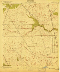
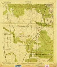
Aldine stands as a primary railroad siding and settlement in Harris County just after the First World War, situated at the intersection of critical early transit lines. The landscape is defined by the meandering courses of Greens Bayou and Halls Bayou, which cut through the coastal prairie. Transportation patterns reflect the shift from rural trails to a more structured grid, with Kuyendahl Road and Air Line Road providing vital north-south connectivity. Local life is anchored by family and community landmarks such as the Hargrove School and a small Cem located near the bayou's edge. The presence of the International and Great Northern railroad highlights the era's reliance on rail for the local economy, connecting this agricultural periphery to the growing Gulf Coast markets before the massive suburban expansion of later decades.
Find a feature on this map
15 named features on this map. Tap any name to fly to it.
Don’t see what you’re looking for? This feature index may not catch every label — zoom into the map to look around manually.
Map Details
Editions of this 1919 Aldine Map
3 editions found
Other maps of this area

1915 · Houston Heights
USGS Topo · 1:24,000

1915 · Hillendahl
USGS Topo · 1:24,000

1916 · Aldine
USGS Topo · 1:24,000

1916 · Settegast
USGS Topo · 1:24,000

1916 · Louetta
USGS Topo · 1:24,000

1916 · Satsuma
USGS Topo · 1:24,000

1916 · Humble
USGS Topo · 1:24,000

1916 · Spring
USGS Topo · 1:24,000
1918 · Hillendahl
USGS Topo · 1:31,680
1919 · Humble
USGS Topo · 1:31,680