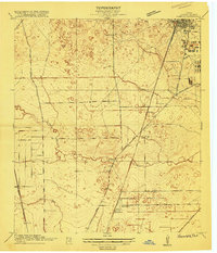
1916 Map of Humble
USGS Topo · Published 1916About this map
Humble and its surrounding coastal prairie landscape are captured here during a period of significant regional growth in Harris County. The settlement pattern is defined by the intersection of rail and road, with the Great Northern and International railroad serving as a primary spine through the territory. Small communities like Bender and Mt Houston appear along these transit corridors, while the presence of the Higgs School suggests the established rural community life of the mid-1910s.
Find a feature on this map
21 named features on this map. Tap any name to fly to it.
Don’t see what you’re looking for? This feature index may not catch every label — zoom into the map to look around manually.
Map Details
Editions of this 1916 Humble Map
2 editions found
Other maps of this area

1915 · Houston Heights
USGS Topo · 1:24,000

1916 · Aldine
USGS Topo · 1:24,000

1916 · Settegast
USGS Topo · 1:24,000

1916 · Fauna
USGS Topo · 1:24,000

1916 · Harmaston
USGS Topo · 1:24,000

1916 · Moonshine Hill
USGS Topo · 1:24,000

1916 · Humble
USGS Topo · 1:24,000

1916 · Spring
USGS Topo · 1:24,000

1919 · Aldine
USGS Topo · 1:31,680

1919 · Humble
USGS Topo · 1:31,680