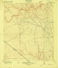
1916 Map of Satsuma
USGS Topo · Published 1916About this map
Timber and rail define the landscape of northern Harris County in this 1916 survey, where the industry is anchored by a cluster of operations including Christy Sawmill, Anderson Sawmill, and Wrothe Sawmill. The tiny settlement of Satsuma sits along the Houston and Texas Central Railroad, serving as a vital link for the transit of goods and people across the plains. To the east, North Houston marks the convergence of early transportation corridors like the Trinity and Brazos Valley Road and West Montgomery Road. The terrain is deeply carved by drainage systems, most notably Cypress Creek and its tributaries Pillot Gully and Faulkey Gully. Local educational life is represented by the isolated Fuchs School, while the presence of family-named water bodies like Pillot Lake suggests the deep roots of early area settlers before the heavy urbanization of later decades.
Find a feature on this map
24 named features on this map. Tap any name to fly to it.
Don’t see what you’re looking for? This feature index may not catch every label — zoom into the map to look around manually.
Map Details
Editions of this 1916 Satsuma Map
3 editions found
Other maps of this area

1915 · Houston Heights
USGS Topo · 1:24,000

1915 · Cypress
USGS Topo · 1:24,000

1915 · Addicks
USGS Topo · 1:24,000

1915 · Hillendahl
USGS Topo · 1:24,000

1916 · Rose Hill
USGS Topo · 1:24,000

1916 · Aldine
USGS Topo · 1:24,000

1916 · Louetta
USGS Topo · 1:24,000

1916 · Satsuma
USGS Topo · 1:24,000

1916 · Spring
USGS Topo · 1:24,000

1918 · Cypress
USGS Topo · 1:31,680