1950s Maps of Coopers Alley L-Head, Corpus Christi
Explore 4 historic maps of Coopers Alley L-Head from the 1950s. These maps offer a rare glimpse into what life looked like during the 1950s — showing old roads, neighborhoods, homes, and landmarks that have changed or disappeared over time.
Whether you're researching your family's past, planning a metal detecting trip, or studying how Coopers Alley L-Head's landscape evolved across the 1950s, these high-resolution maps are a powerful tool for exploring the history of this region.
- Focus on a specific era: All maps on this page are from the 1950s, giving you a focused view of this time period.
- See what’s changed: Compare century-old streets, trails, and buildings to today's modern landscape using overlays and satellite layers.
- Research with precision: Use these maps for genealogy, historical research, land use analysis, or educational projects.
- View, download, or print: Maps are fully viewable online in high resolution, and can be downloaded or printed for your own records.
Start exploring Coopers Alley L-Head's history through authentic maps from the 1950s. This is your window into the past.
Coopers Alley L-Head, Corpus Christi maps
(4)- 1950 Map of Corpus Christi, 1953 Print
 1950 Corpus Christi1953 Print · USGSThe South Texas coast comes into focus during the early fifties, showing the interplay between booming oil fields and expansive ranching operations. Genealogists and historians can trace the Texas Mexican rail line through Kingsville or locate heritage sites like Chapman Ranch and Riviera Beach.
 - 1951 Map of Corpus Christi, 1952 Print
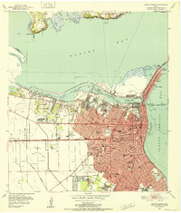 1951 Corpus Christi1952 Print · USGSCorpus Christi at the dawn of the fifties showcases a bustling deep-water port and a rapidly expanding Texas coastal city. Genealogists and local historians can trace family locations through dozens of neighborhood landmarks, including Rose Hill Cem, St Therese Sch, and Cliff Maus Airport.
 - 1951 Map of Corpus Christi, 1952 Print
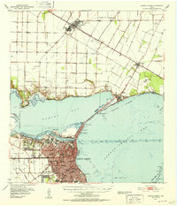 1951 Corpus Christi1952 Print · USGSCorpus Christi and its surrounding bays were undergoing significant industrial and maritime growth in the early fifties. Genealogists and local historians can trace family roots at Bellevue Cem or locate former landmarks like Rosita Ranch and the Cliff Maus Airport.2 unique versions available
 - 1956 Map of Corpus Christi
 1956 Corpus Christi1956 Print · USGSThe South Texas coast and the burgeoning port of Corpus Christi are captured here during the mid-fifties. Genealogists and historians can trace the rail-and-oil economy through labels like Robstown Airpark, Chapman Ranch, and the Missouri Pacific railroad.
End of results
Showing maps 1-4 of 4
Frequently asked questions
- What are the different types of historical maps available for Coopers Alley L-Head?
- What is the oldest map of Coopers Alley L-Head?
- Where can I purchase historical maps of Coopers Alley L-Head for my home or office?
- Where can I download high-res historical maps of Coopers Alley L-Head?
- Are there historical topographic maps available for Coopers Alley L-Head?
- Is there historical aerial imagery available for Coopers Alley L-Head?
- Where are historical maps of Coopers Alley L-Head sourced from?