1900s (20th Century) Maps of Bovina, Texas
Explore 5 historic maps of Bovina from the 1900s (20th Century). These maps offer a rare glimpse into what life looked like during the 1900s — showing old roads, neighborhoods, homes, and landmarks that have changed or disappeared over time.
Whether you're researching your family's past, planning a metal detecting trip, or studying how Bovina's landscape evolved across the 1900s, these high-resolution maps are a powerful tool for exploring the history of this region.
- Focus on a specific era: All maps on this page are from the 1900s, giving you a focused view of this time period.
- See what’s changed: Compare century-old streets, trails, and buildings to today's modern landscape using overlays and satellite layers.
- Research with precision: Use these maps for genealogy, historical research, land use analysis, or educational projects.
- View, download, or print: Maps are fully viewable online in high resolution, and can be downloaded or printed for your own records.
Start exploring Bovina's history through authentic maps from the 1900s. This is your window into the past.
Bovina, TX maps
(5)- 1954 Map of Clovis, 1966 Print
 1954 Clovis1966 Print · USGSThe High Plains of the Texas-New Mexico borderland come alive in this mid-century survey as the region's agricultural and rail networks reached their peak. Trace family roots and local history through features like Cannon AFB, the massive Sand Hills, and busy rail towns such as Friona and Littlefield.4 unique versions available
 - 1958 Map of Clovis
 1958 Clovis1958 Print · USGSThe High Plains of the New Mexico-Texas borderlands are captured here in the late fifties, during a period of significant military and agricultural expansion. Genealogists and historians can trace the rail-side growth of Clovis, the operations at Clovis Air Force Base, and the rural layout of communities like Muleshoe and Hereford.
 - 1965 Map of Bovina, 1968 Print
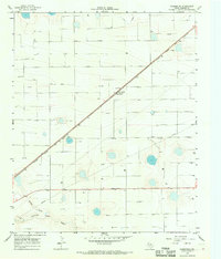
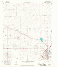 1965 Bovina1968 Print · USGSBovina and the surrounding Texas Panhandle plains are shown here in the mid-sixties, centered on the region's vital rail-and-ranching economy. Researchers can trace the path of the Atchison Topeka and Santa Fe and locate local landmarks like the Cem or Mustang Lake.2 unique versions available
 - 1965 Map of Parmerton, 1968 Print
 1965 Parmerton1968 Print · USGSParmer County, Texas, is captured in the mid-1960s as a landscape of rail-driven agriculture and high-plains drainage systems. Researchers can locate the Parmerton siding along the Atchison Topeka and Santa Fe railroad, marked by its Grain Elevator and the seasonal waters of Running Water Draw.
 - 1985 Map of Hereford
 1985 Hereford1985 Print · USGSThe High Plains of the Texas Panhandle are captured here during the mid-eighties, a period defined by vast agricultural grids and critical rail corridors. Genealogists and local historians can trace the footprint of settlements like Hereford, Dimmitt, and Bovina, alongside the Buffalo Lake National Wildlife Refuge.2 unique versions available
End of results
Showing maps 1-5 of 5
Top cities near Bovina
Frequently asked questions
- What are the different types of historical maps available for Bovina?
- What is the oldest map of Bovina?
- Where can I purchase historical maps of Bovina for my home or office?
- Where can I download high-res historical maps of Bovina?
- Are there historical topographic maps available for Bovina?
- Is there historical aerial imagery available for Bovina?
- Where are historical maps of Bovina sourced from?