1900s (20th Century) Maps of Pecos, Texas
Explore 8 historic maps of Pecos from the 1900s (20th Century). These maps offer a rare glimpse into what life looked like during the 1900s — showing old roads, neighborhoods, homes, and landmarks that have changed or disappeared over time.
Whether you're researching your family's past, planning a metal detecting trip, or studying how Pecos's landscape evolved across the 1900s, these high-resolution maps are a powerful tool for exploring the history of this region.
- Focus on a specific era: All maps on this page are from the 1900s, giving you a focused view of this time period.
- See what’s changed: Compare century-old streets, trails, and buildings to today's modern landscape using overlays and satellite layers.
- Research with precision: Use these maps for genealogy, historical research, land use analysis, or educational projects.
- View, download, or print: Maps are fully viewable online in high resolution, and can be downloaded or printed for your own records.
Start exploring Pecos's history through authentic maps from the 1900s. This is your window into the past.
Pecos, TX maps
(8)- 1921 Map of Toyah
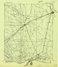 1921 Toyah1921 Print · USGSReeves County at the dawn of the highway era is documented here, showing the junction of major rail lines and early transcontinental motor routes. Researchers can trace family ranching history and railroad development through Toyah, Saragosa, and the VR Ranch.
 - 1931 Map of Barstow
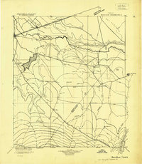 1931 Barstow1931 Print · USGSWest Texas ranching and early oil exploration meet along the Pecos River during the early thirties. Trace family ranch sites like Eclipse Ranch and Courtney Ranch or locate early rural education hubs at Welcome School.
 - 1954 Map of Pecos, 1964 Print
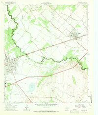
 1954 Pecos1964 Print · USGSMid-century West Texas reveals a landscape of expanding oil fields and cattle ranching along the winding Pecos River. Local historians can trace family ranch lands like Goodrich Ranch, follow the Texas and Pacific rails, or locate the historic Horsehead Crossing.3 unique versions available
 - 1957 Map of Pecos
 1957 Pecos1957 Print · USGSWest Texas in the mid-fifties is a landscape of desert oil fields and vital rail corridors. Researchers can trace the sprawling Pyote Air Force Base, the historic Horsehead Crossing, and the rail stops at Mentone and Saragosa.
 - 1963 Map of Pecos East, 1966 Print
 1963 Pecos East1966 Print · USGSReeves and Ward Counties appear in the early sixties as the irrigation and rail infrastructure of the Trans-Pecos reaches its peak. Genealogists can trace family plots at Barstow Cem or locate community centers like Mt Zion Ch and the Pecos Sch.2 unique versions available
 - 1971 Map of Worsham, 1973 Print
 1971 Worsham1973 Print · USGSReeves County agriculture and aviation come into focus in the early seventies along the Pecos Valley Southern rail line. Researchers can locate specialized sites like the Texas Agricultural Experiment Station and the Worsham Airfield.
 - 1971 Map of Pecos West, 1973 Print
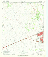 1971 Pecos West1973 Print · USGSReeves County at the start of the 1970s reveals a bustling rail hub and growing community. Local researchers can trace the development of Pecos neighborhoods, locate family plots at Mount Evergreen Cem, or identify landmarks like the Drive-in Theater.2 unique versions available
 - 1986 Map of Pecos
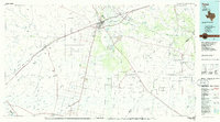 1986 Pecos1986 Print · USGSWest Texas in the mid-eighties reveals a landscape of desert draws and growing energy infrastructure centered on the Pecos River. Researchers can trace old rail lines, family burials at Mount Evergreen Cem, and rural outposts like Toyah or Saragosa.2 unique versions available
End of results
Showing maps 1-8 of 8
Top cities near Pecos
Top neighborhoods of Pecos
Frequently asked questions
- What are the different types of historical maps available for Pecos?
- What is the oldest map of Pecos?
- Where can I purchase historical maps of Pecos for my home or office?
- Where can I download high-res historical maps of Pecos?
- Are there historical topographic maps available for Pecos?
- Is there historical aerial imagery available for Pecos?
- Where are historical maps of Pecos sourced from?