1970s Maps of Pecos, Texas
Explore 2 historic maps of Pecos from the 1970s. These maps offer a rare glimpse into what life looked like during the 1970s — showing old roads, neighborhoods, homes, and landmarks that have changed or disappeared over time.
Whether you're researching your family's past, planning a metal detecting trip, or studying how Pecos's landscape evolved across the 1970s, these high-resolution maps are a powerful tool for exploring the history of this region.
- Focus on a specific era: All maps on this page are from the 1970s, giving you a focused view of this time period.
- See what’s changed: Compare century-old streets, trails, and buildings to today's modern landscape using overlays and satellite layers.
- Research with precision: Use these maps for genealogy, historical research, land use analysis, or educational projects.
- View, download, or print: Maps are fully viewable online in high resolution, and can be downloaded or printed for your own records.
Start exploring Pecos's history through authentic maps from the 1970s. This is your window into the past.
Pecos, TX maps
(2)- 1971 Map of Worsham, 1973 Print
 1971 Worsham1973 Print · USGSReeves County agriculture and aviation come into focus in the early seventies along the Pecos Valley Southern rail line. Researchers can locate specialized sites like the Texas Agricultural Experiment Station and the Worsham Airfield.
 - 1971 Map of Pecos West, 1973 Print
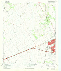 1971 Pecos West1973 Print · USGSReeves County at the start of the 1970s reveals a bustling rail hub and growing community. Local researchers can trace the development of Pecos neighborhoods, locate family plots at Mount Evergreen Cem, or identify landmarks like the Drive-in Theater.2 unique versions available
End of results
Showing maps 1-2 of 2
Top cities near Pecos
Top neighborhoods of Pecos
Frequently asked questions
- What are the different types of historical maps available for Pecos?
- What is the oldest map of Pecos?
- Where can I purchase historical maps of Pecos for my home or office?
- Where can I download high-res historical maps of Pecos?
- Are there historical topographic maps available for Pecos?
- Is there historical aerial imagery available for Pecos?
- Where are historical maps of Pecos sourced from?