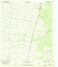
1971 Map of Worsham
USGS Topo · Published 1973About this map
Worsham and its surrounding agricultural landscape occupy this Reeves County terrain during the early 1970s. The map illustrates a region defined by arid-land management and transport, anchored by the Texas Agricultural Experiment Station and the linear path of the Pecos Valley Southern railroad. The presence of numerous wells and drill holes underscores the subterranean mineral and water exploration common to West Texas during this era, while the Worsham Airfield serves as a small but vital hub for local aviation. The landscape is carved by natural drainage systems like Salt Draw and Toyah Creek, which contrast with the engineered grid of fence lines and pipelines. Further south, the settlement of Valley Farm and a designated Borrow Pit provide evidence of local residence and utility operations in this sparsely settled expanse.
Find a feature on this map
8 named features on this map. Tap any name to fly to it.
Don’t see what you’re looking for? This feature index may not catch every label — zoom into the map to look around manually.
Map Details
Editions of this 1971 Worsham Map
This is the sole edition of this map. No revisions or reprints were ever made.
Other maps of this area

1921 · Toyah
USGS Topo · 1:125,000

1931 · Barstow
USGS Topo · 1:125,000

1954 · Pecos
USGS Topo · 1:250,000

1955 · Saragosa
USGS Topo · 1:62,500

1957 · Pecos
USGS Topo · 1:250,000

1963 · Pecos East
USGS Topo · 1:24,000

1963 · Toyah Lake
USGS Topo · 1:24,000

1970 · Hermosa SW
USGS Topo · 1:24,000
1970 · Hermosa
USGS Topo · 1:24,000
1970 · Saragosa NW
USGS Topo · 1:24,000