Loading...
Loading map...1931 Map of Barstow
USGS Topo · Published 1931About this map
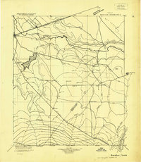
The Pecos River serves as the primary boundary line between Ward and Reeves counties in this early 1930s survey. This era in West Texas was defined by the intersection of traditional ranching and the emerging oil industry, as seen in labels for Southern Crude and the World Kloh No. 1 oil well. The infrastructure of the region reflects a developing landscape where the Texas Pacific railroad and State Highway No. 1 connect the hubs of Barstow and Pecos.
Find a feature on this map
53 named features on this map. Tap any name to fly to it.
Don’t see what you’re looking for? This feature index may not catch every label — zoom into the map to look around manually.
Map Details
Date Portrayed1931
Date Published1931
PublisherU.S. Geological Survey
Map TypeTopographic
Scale1:125,000
Physical Dimensions19.1 x 21.9 inches
Editions of this 1931 Barstow Map
This is the sole edition of this map. No revisions or reprints were ever made.
Historical Maps of Pecos Through Time
1 maps found
Featured Locations
Source Details
SourceU.S. Geological Survey
CopyrightPublic Domain