1957 Map of Pecos
USGS Topo · Published 1957About this map
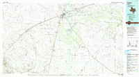
The Pecos River carves a diagonal path through this 1950s West Texas landscape, serving as a boundary for counties such as Loving, Ward, and Pecos. This era represents a peak for the region's energy economy, evidenced by the dense concentration of petroleum infrastructure including the Chapel Oil Field, Goldsmith Oil Field, and the University-Waddell Oil and Gas Field. The industrial character is balanced by significant military and transport hubs like the Pyote Air Force Base and the Texas and Pacific RR line connecting towns like Monahans, Pyote, and Barstow.
Find a feature on this map
120 named features on this map. Tap any name to fly to it.
Don’t see what you’re looking for? This feature index may not catch every label — zoom into the map to look around manually.
Map Details
Editions of this 1957 Pecos Map
This is the sole edition of this map. No revisions or reprints were ever made.