
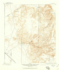
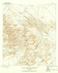
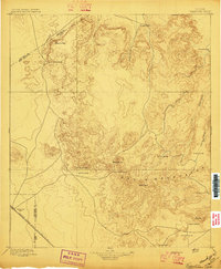
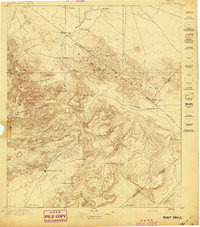
1928 Map of Kent
USGS Topo · Published 1928About this map
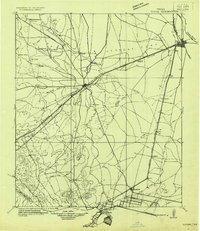
The Texas Pacific R.R. corridor serves as the primary artery through this Trans-Pecos landscape, where the high desert floor meets the rising peaks of the Davis Mountains. Following the rail line and State Highway No. 1, early West Texas settlements like Kent and Boracho provide vital stops in an arid environment defined by seasonal drainages like China Draw and Salt Draw. This 1928 reconnaissance by N. H. Darton illustrates a period when automotive travel began to follow the historic Old Spanish Trail, yet the region remained dominated by large-scale ranching operations such as Diamond Ranch and small outposts like Seay and Levinson. Water sources were the critical drivers of settlement here, marked by isolated points like San Martine Spring and Kildogan Spring. The topography transitions from the flat plains near the Main Toyah Road to prominent landmarks including Gomez Peak and the high ridges of San Martine, showing the intersection of Culberson, Reeves, and Jeff Davis counties.
Find a feature on this map
44 named features on this map. Tap any name to fly to it.
Don’t see what you’re looking for? This feature index may not catch every label — zoom into the map to look around manually.
Map Details
Editions of this 1928 Kent Map
This is the sole edition of this map. No revisions or reprints were ever made.
Other maps of this area

1892 · Chispa
USGS Topo · 1:125,000
1894 · Valentine
USGS Topo · 1:125,000
1894 · Fort Davis
USGS Topo · 1:125,000

1895 · Chispa
USGS Topo · 1:125,000
1897 · Valentine
USGS Topo · 1:125,000
1897 · Fort Davis
USGS Topo · 1:125,000

1897 · Chispa
USGS Topo · 1:125,000

1906 · Van Horn
USGS Topo · 1:125,000
1921 · Toyah
USGS Topo · 1:125,000
1943 · Valentine
USGS Topo · 1:125,000