1900s (20th Century) Maps of Ballinger, Texas
Explore 7 historic maps of Ballinger from the 1900s (20th Century). These maps offer a rare glimpse into what life looked like during the 1900s — showing old roads, neighborhoods, homes, and landmarks that have changed or disappeared over time.
Whether you're researching your family's past, planning a metal detecting trip, or studying how Ballinger's landscape evolved across the 1900s, these high-resolution maps are a powerful tool for exploring the history of this region.
- Focus on a specific era: All maps on this page are from the 1900s, giving you a focused view of this time period.
- See what’s changed: Compare century-old streets, trails, and buildings to today's modern landscape using overlays and satellite layers.
- Research with precision: Use these maps for genealogy, historical research, land use analysis, or educational projects.
- View, download, or print: Maps are fully viewable online in high resolution, and can be downloaded or printed for your own records.
Start exploring Ballinger's history through authentic maps from the 1900s. This is your window into the past.
Ballinger, TX maps
(7)- 1921 Map of Hatchel
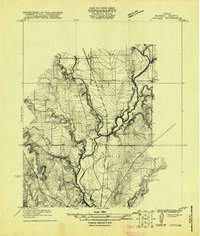 1921 Hatchel1921 Print · USGSRunnels County enters the early twenties as a landscape of creek-side schools and steam-era rail lines. Family historians can locate Eagle School, Runnels School, and the Runnels Cemetery along the Abilene and Southern route.
 - 1921 Map of Spur Creek
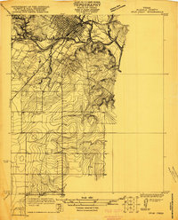 1921 Spur Creek1921 Print · USGSBallinger and the surrounding Runnels County countryside are captured here in the early 1920s during a period of established riverfront settlement. Genealogists can locate old family-named sites and rural institutions like Big Rock School, Dry Ridge School, and the Gulf Colorado and Santa Fe rail line.
 - 1932 Map of Paint Rock
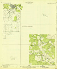 1932 Paint Rock1932 Print · USGSThe northern edge of the Edwards Plateau comes into focus in the early 1930s as the rail lines reached into Concho County. Genealogists and historians can trace the rural school districts of the day, including Dry Ridge Sch and Mapes Sch, or locate the family-named bluffs along the Concho River.2 unique versions available
 - 1954 Map of Brownwood, 1955 Print
 1954 Brownwood1955 Print · USGSCentral Texas in the early fifties shows a landscape of rail-linked cattle towns and winding river valleys before modern highway expansion. Genealogists and historians can trace family-named peaks and vanished rail stops like Trickham, Santa Anna, and the Brady Mountains.3 unique versions available
 - 1967 Map of Hatchel, 1969 Print
 1967 Hatchel1969 Print · USGSRunnels County in the late sixties shows the intersection of the Abilene and Southern rail line and a network of winding creeks. Researchers can locate the Old Runnels Cem and traces of local life at the Rodeo Ground or the Drive-in Theater.2 unique versions available
 - 1967 Map of Ballinger, 1970 Print
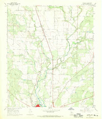
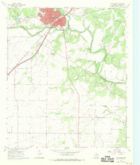 1967 Ballinger1970 Print · USGSBallinger and the surrounding Texas plains are captured here in the late sixties as the local economy balanced rail transport and oil production. Researchers can trace the legacy of the Atchison Topeka and Santa Fe and locate family landmarks like Evergreen Cem and Carver Sch.2 unique versions available
 - 1985 Map of Coleman
 1985 Coleman1985 Print · USGSCentral Texas ranching and rail country comes to life in the 1980s as the Atchison Topeka and Santa Fe line cuts through Coleman. Researchers can trace old settlements and topography from Robinson Peak to the waters of Lake Brownwood State Park.2 unique versions available
End of results
Showing maps 1-7 of 7
Top cities near Ballinger
Frequently asked questions
- What are the different types of historical maps available for Ballinger?
- What is the oldest map of Ballinger?
- Where can I purchase historical maps of Ballinger for my home or office?
- Where can I download high-res historical maps of Ballinger?
- Are there historical topographic maps available for Ballinger?
- Is there historical aerial imagery available for Ballinger?
- Where are historical maps of Ballinger sourced from?