1950s Maps of Flying V Ranch, Texas
Explore 3 historic maps of Flying V Ranch from the 1950s. These maps offer a rare glimpse into what life looked like during the 1950s — showing old roads, neighborhoods, homes, and landmarks that have changed or disappeared over time.
Whether you're researching your family's past, planning a metal detecting trip, or studying how Flying V Ranch's landscape evolved across the 1950s, these high-resolution maps are a powerful tool for exploring the history of this region.
- Focus on a specific era: All maps on this page are from the 1950s, giving you a focused view of this time period.
- See what’s changed: Compare century-old streets, trails, and buildings to today's modern landscape using overlays and satellite layers.
- Research with precision: Use these maps for genealogy, historical research, land use analysis, or educational projects.
- View, download, or print: Maps are fully viewable online in high resolution, and can be downloaded or printed for your own records.
Start exploring Flying V Ranch's history through authentic maps from the 1950s. This is your window into the past.
Flying V Ranch, TX maps
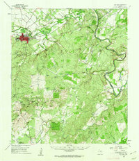
(3)- 1954 Map of Brownwood, 1955 Print
 1954 Brownwood1955 Print · USGSCentral Texas in the early fifties shows a landscape of rail-linked cattle towns and winding river valleys before modern highway expansion. Genealogists and historians can trace family-named peaks and vanished rail stops like Trickham, Santa Anna, and the Brady Mountains.3 unique versions available
 - 1959 Map of Bear Hollow, 1960 Print
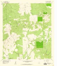 1959 Bear Hollow1960 Print · USGSSan Saba County ranchlands are captured here in the late fifties, showcasing a landscape of isolated homesteads and vital water tanks. Researchers can locate family landmarks like Montgomery Cem or trace the early footprint of the Flying V Ranch and Horse Mtn.
 - 1959 Map of San Saba, 1962 Print
 1959 San Saba1962 Print · USGSSan Saba sits at the heart of this Texas Hill Country landscape during the late fifties, where the river meets a network of ranching roads. Researchers can trace family lines through Pecan Grove Cem and Terry Cem or locate the old High Valley Sch.
End of results
Showing maps 1-3 of 3
Top cities near Flying V Ranch
Frequently asked questions
- What are the different types of historical maps available for Flying V Ranch?
- What is the oldest map of Flying V Ranch?
- Where can I purchase historical maps of Flying V Ranch for my home or office?
- Where can I download high-res historical maps of Flying V Ranch?
- Are there historical topographic maps available for Flying V Ranch?
- Is there historical aerial imagery available for Flying V Ranch?
- Where are historical maps of Flying V Ranch sourced from?